uk 75

ACCESS: Above Top Secret
Senior Member
Joined
27 September 2006
Messages
6,622
Reaction score
7,443
Ever since the first Zeppelin raids in World War 1 the vulnerability of the civilian population of the UK to attack from the air has been a major factor in shaping our armed forces.
The tile "Air Defence of Great Britain" comes from the organisation set up to meet the only air threat imagined in the 20s, from France.
By 1936 filmgoers in Britain were chilled by the bombing of a British city depicted in the movie "Things to Come". Politicians shared this fear.
In reality Germany could not mount a serious bombing campaign against Britain from its own airfields. But Baldwin and Chamberlain were both mesmerised by the idea of the Luftwaffe bombing from Day One of a war.
While it cost vital years in facing up to Hitler the government were at least prompted to create the RAF fighters backed by radar that resisted German air attacks when they came.
After 1945 the power of the Atom and then the Hydrogen bomb emphasised deterrence rather than defence. Once the Soviet Union acquired the means to bomb Britain defence of the airfields where US and then British bombers would set off was more important than trying to protect cities.
Although Polaris replaced the V force in 1969 the remaining theatre nuclear RAF and USAF aircraft still had to be defended from air attack in the opening stages of a war.
The end of the Cold War in the 90s saw a serious reduction in the RAF air defence effort which has continued until the re-emergence of Russia as a threat.
Some idea of what might be required to defend the UK can be gained from this thread:

https://www.secretprojects.co.uk/threads/guam-air-defense.44171/
It is still fashionable to mock Chamberlain for his genuine fear of air warfare but unlike our present politicians he might have begun to prepare for it.
 
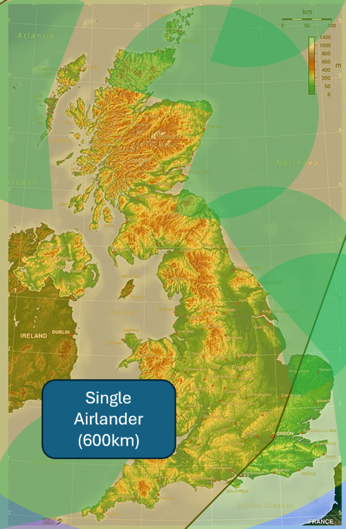
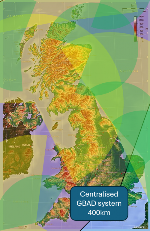
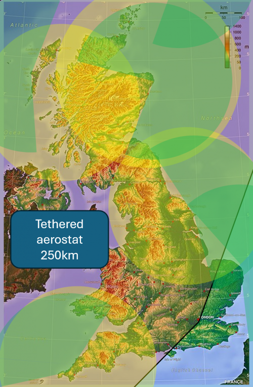
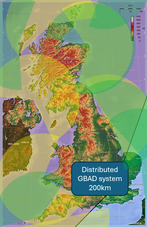
Further to the discussion on the Type 83 page, I thought I'd look a bit further into the options for how the UK could detect cruise missiles and low-flying drones coming in from the Atlantic and North Sea. Writing it all down would be very tedious, so instead I have made some graphics indicating how the ranges and numbers needed compare with the size of the UK. I hope they're useful in any future conversations.
Likely threat sector is in red, radar sectors are in yellow. The ranges are all approximate but the circles are the right size. I have tried to position ground based radars on high points in order to maximise their look-down range and their field of view over the sea.

1758291340429.png 1758291369844.png
1758291663684.png 1758291708861.png
1758291745457.png
This has all made me realise quite how annoying the West coast of Scotland is for missile defence. It has lots of miserable islands with bad weather conditions and nowhere for people to live, but they are too hilly to put the radar on the mainland behind.
 
Last edited:
There's a need to start from what we have right now, which is:

UK Air Surveillance And Control System
RRH - Remote Radar Head

Plus three E-7s with MESA coming soon

AN/TPS-77 - 740km
Type 102 - 460km
LDR-25 - 460km
MESA - 600km look up/370km look down
 
Further to the discussion on the Type 83 page, I thought I'd look a bit further into the options for how the UK could detect cruise missiles and low-flying drones coming in from the Atlantic and North Sea. Writing it all down would be very tedious, so instead I have made some graphics indicating how the ranges and numbers needed compare with the size of the UK. I hope they're useful in any future conversations.
Likely threat sector is in red, radar sectors are in yellow. The ranges are all approximate but the circles are the right size. I have tried to position ground based radars on high points in order to maximise their look-down range and their field of view over the sea.

View attachment 785233

This has all made me realise quite how annoying the West coast of Scotland is for missile defence. It has lots of miserable islands with bad weather conditions and nowhere for people to live, but they are too hilly to put the radar on the mainland behind.
I'm not convinced the northernmost aerostat tethered about 50 miles off the Scottish coast is entirely feasible ;)

The other issue with tethered aerostats is that we regularly get windspeeds in the UK that are going to be marginal for their ability to operate.
 
I'm not convinced the northernmost aerostat tethered about 50 miles off the Scottish coast is entirely feasible ;)

The other issue with tethered aerostats is that we regularly get windspeeds in the UK that are going to be marginal for their ability to operate.
Fixed now, I think! It's always hard to tell with the circles.
I'm not a huge fan of aerostats for that reason, I think Protector AEW or Airlander would be more resilient, more flexible in deployment and also more capable for the cost and regulatory hassle.
I've added the remote radar heads, the map is now getting a little complicated so I'll only show one. I won't add E7 because I think they are too scarce a resource to use on UK defence, which would by necessity be a standing task.
RRHs are in green:
1758262531803.png
 
This is nuts if Fylingdales isn't contributing to the picture.

I wouldn't be locating low level Detection radars in Ulster for looking past Scotland into the North Sea That's just not going to work. You'd have to site on the East Coast.

Ulster and the Hebrides is good for looking north and west.

What the UK is intent on is Jorn-type OTHR to add distant views.

You could site oil rig type platforms for extended low level coverage that could also intigrate passive systems.
 
This is nuts if Fylingdales isn't contributing to the picture.
It's a BMEWS radar (AN/FPS-132 Upgraded Early Warning Radar), not sure what capability it has at lower level and versus aircraft. It may well be its entire duty cycle is completely devoted to high altitude surveillance and tracking.
 
I think Protector AEW or Airlander would be more resilient, more flexible in deployment and also more capable for the cost and regulatory hassle.
Airlander has a max airspeed of about 80mph, it's not going to be able to hold position in a winter storm, or even just autumn weather. For instance if you go look at today's Met Office forecast, most of the country is at 10-20mph winds, but the Mountain Weather Information Service (MWIS.org.uk) has "Southwesterly 35 to 45mph, risk up to 50mph over coastal mountains and toward the far north; may ease a little near Great Glen. Risk becoming widely above 50mph into nighttime." and you can probably double that at altitude for the geostrophic wind. And we're not into autumn yet. Even Protector may find the weather challenging.
 
This is nuts if Fylingdales isn't contributing to the picture.

I wouldn't be locating low level Detection radars in Ulster for looking past Scotland into the North Sea That's just not going to work. You'd have to site on the East Coast.

Ulster and the Hebrides is good for looking north and west.

What the UK is intent on is Jorn-type OTHR to add distant views.

You could site oil rig type platforms for extended low level coverage that could also intigrate passive systems.
Fylingdales is doing deep space search, it isn't there to look for cruise missiles.
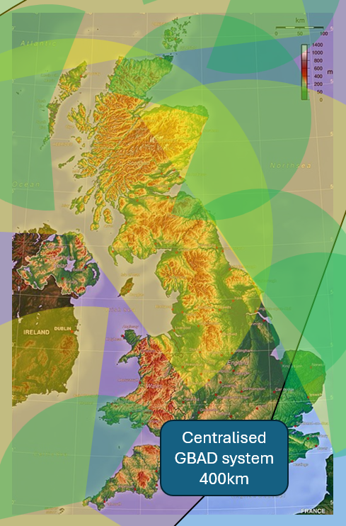
The surface radar (on the 'centralised GBAD system' map) in NI is there to search to the NW out into the Atlantic, and to track missiles, aircraft, ships etc. as they head SW into the Irish Sea towards England. The arc goes across Scotland because it lies between those sectors, not because I intended the North Sea to be part of its search area.
An OHR would be great, especially if it had the 180-degree arc of the Western Australia array and could look out simultaneously across Eastern Europe and the North Atlantic. However, JORN's minimum detection range is 1000km; if positioned in East Anglia, an array wouldn't be able to see anything this side of Shetland to the north or Prague to the west. A UK OHR would therefore be a NATO-wide asset monitoring the air and sea from Svalbard through Moscow to Murmansk, and so not very relevant to the air defence of the UK itself. That said, I think as a NATO-wide effort it would be very useful (the French already have one).
Offshore platforms or 'SAMPSON on a wind turbine pole' would be great if they can be guaranteed not to need to much maintenance. If not, the RB1s would have to pick up an extra role, methinks.
 
Airlander has a max airspeed of about 80mph, it's not going to be able to hold position in a winter storm, or even just autumn weather. For instance if you go look at today's Met Office forecast, most of the country is at 10-20mph winds, but the Mountain Weather Information Service (MWIS.org.uk) has "Southwesterly 35 to 45mph, risk up to 50mph over coastal mountains and toward the far north; may ease a little near Great Glen. Risk becoming widely above 50mph into nighttime." and you can probably double that at altitude for the geostrophic wind. And we're not into autumn yet. Even Protector may find the weather challenging.
When operating with crew Airlander's endurance is limited far more by their endurance than by its own fuel load. If it has to go at full power into the wind it can, and the only change will be that the crews have to rotate slightly faster. I was once told by a HAV employee that it has the similar weather ratings to a conventional plane. The limit to airfield operations is 30kts, but 5 days endurance and 3000 mile range gives plenty of leeway to either ride out a storm or relocate, and that's more than an aerostat could take, I think. Airlander also has significantly greater payload than most aerostats. As the benchmark for the maps I used the same radar range as the E2D, but it could definitely go larger and more powerful nearly up to Wedgetail size. Airlander 50 would significantly exceed Wedgetail, but that will only be available around 2035 rather than 2029 for Airlander 10.
The mountain stat is not representative. Hills act as giant venturis forcing air through valleys and over ridges, so it is always significantly windier on mountainsides than anywhere else. Competition gliders, for example, use that for altitude and endurance records.
 
Last edited:

Similar threads

Back
Top Bottom