North Korea's Military Reconnaissance Satellite "Malligyong-1"

KUMA

ACCESS: Confidential
Joined
9 October 2020
Messages
154
Reaction score
473
Website
weibo.com
1.The start

A report was made on the work of the Seventh Central Committee of the Party from January 5 to 7, Juche 110 (2021) at the Eighth Congress of the Workers' Party of Korea (WPK).
In this report, we can easily find the following interesting contents:

Original KCNA text
The report made public with pride that the standard of the goal in the modernization of medium-sized submarine was set correctly and it was remodelled experimentally to open up a bright prospect for remarkably enhancing the existing subsurface operational capabilities of our navy, that the design of new nuclear-powered submarine was researched and was in the stage of final examination and the designing of various electronic weapons, unmanned striking equipment, means of reconnaissance and detection and military reconnaissance satellite were completed, and that other achievements were made in national defence research of gigantic significance in developing the People's Army into a powerful one with the strongest military muscle in the world.

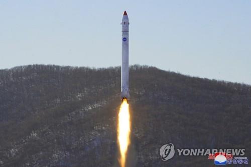
At first, this did not give me much hope for Ether, but after the HS-8 test launch, I began to wait for the news of the new satellite, and North Korea did not keep me waiting.
During several missile tests this year (2022), new satellite test components were sent into the space with missiles. Some of its images allow us to see the capabilities of North Korea's future military satellites
2.What did they test ?

In February 27 and March 5, 2022 , North Korea conducted two "Important Test for Developing Reconnaissance Satellite":

Original KCNA text
The test helped the NADA and the Academy of Defence Science to confirm the characteristics and working accuracy of high definition photographing system, data transmission system and attitude control devices by conducting vertical and oblique photographing of a specific area on earth with cameras to be loaded on the reconnaissance satellite.
Original KCNA text
Through the test, the NADA confirmed the reliability of data transmission and reception system of the satellite, its control command system and various ground-based control systems.

The first test (2022.2.27) is the most critical of the two tests, because in later reports, some of the photos taken in this experiment were shown. Although they were blurred, they could still be analyzed.

3.What image we get ?

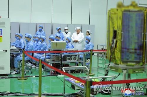
In March 10, 2022, Kim Jong Un inspected the National Aerospace Development Administration (NADA), and in the report photos, we got these images:

P1:
A.png

P2:
B.png

Although these photos are blurred, we can make them as clear as possible through deconvolution. by this way, we can get more information than the original images.

p.png


4.My analysis


F1.png

In P2, we can determine the shooting time, shooting area, shooting method, camera height when shooting, and possible resolution:

Photographic mode - vertical photographing
Shooting area - Pyongannam-do,Anju near by
Photographic height - 591km
resolution - Probably 2.0Xm (Panchromatic)

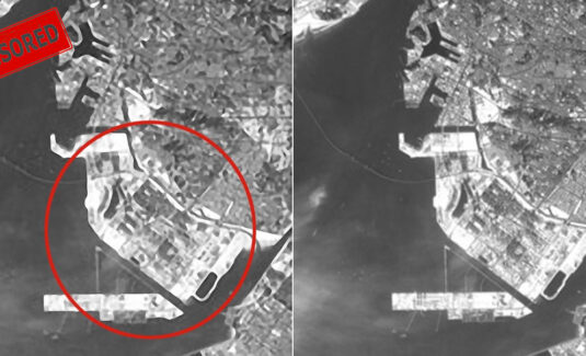
The values of resolution are ambiguous. How can we determine our conjecture? Let's look at the partially captured image shown in P1.

Combining my restored image with the three resolutions of the same area provided by 38N, it is easy to find that, despite being blurred, the resolution level is indeed close to the level of about 3m:

卫星分析.jpg

However, we still have one more information to analyze: The swath width.Through the overlay analysis of P2, we can get this data:

FX.png

What this satellite may look like:
Kim Chaek University of Technology(KUT) showed a CGI in its own school news on the school website, which may show the future satellite's shape:

article181.jpg

Interestingly, the shape is very similar to Kompsat-3/3A.

Now we can know the satellite details:

Working on ~600km SSO
Resolution ~2m
Swath width ~13km
Configuration may similar to Kompsat-3/3A


5.The future......

When Kim Jong Un Inspects National Aerospace Development Administration,he said:

it is our Party's important strategic and tactical policy on bolstering the national defence capability to keep a close eye on and distinguish the character of hostile military actions against the DPRK committed by the aggression troops of the U.S. imperialism and its vassal forces in and around the Korean Peninsula and enhance the capability for controlling situation and improve the rapid counteraction capability of the armed forces of the state according to the relevant situations. And he set forth the militant goals related to the development and operation of the reconnaissance satellite in the period of the five-year plan to implement this policy.

Interestingly, the words about reconnaissance satellites at the end are vague in the English version, but this is very clear in the Chinese version:

开发和运用军事侦察卫星的目的在于,向共和国武装力量实时提供美帝国主义侵略军及其追随势力在南朝鲜地区、日本地区和太平洋上的反朝军事行动情报,党中央全面支持国家宇宙开发局为实现这一目标,在五年计划期间把大量侦察卫星多角布置在太阳同步极地轨道上,筑牢依靠卫星的侦查情报搜集能力的决心。(During the five-year plan period, a large number of reconnaissance satellites will be placed in the sun synchronous polar orbit at multiple angles to strengthen the determination to rely on the satellite's ability to collect reconnaissance information)

It seems that a new satellite constellation is about to appear, and the space may be more lively in the future.

My English is not good. The above text is completed with translation software, I hope the meaning will not change too much.:)
 
Interesting Find.

I'm curious with the size of the Satellite. as it would determine the mirror dimension it can carry.

The potentials are big, and can be beyond scope of military. North Korea can be one of the "alternative" commercial satellite imagery provider. Their ESM Satellite can also be a revenue source.
Thank you! I haven't thought about this possibility before!
Unfortunately, there is too little information to confirm the size of the satellite, But I will continue to pay attention to relevant news.:D
 
Interesting Find.

I'm curious with the size of the Satellite. as it would determine the mirror dimension it can carry.

The potentials are big, and can be beyond scope of military. North Korea can be one of the "alternative" commercial satellite imagery provider. Their ESM Satellite can also be a revenue source.
By the way, North Korea's future satellites may not only be optical satellites, but also SAR satellites.

At last year's Symposium on Space Science and Technology-2021(see below), the equipment under development was mentioned, including SAR radar besides satellite camera.

However, haven't seen the physical test and related news of SAR yet.

Original KCNA text
Drawing the attention of experts were treatises that solved in a fresh way the urgent matters arising in further developing the technologies of satellite development, control, observation and communication like the one for manufacturing and testing satellite and fittings, the one for satellite navigation and control of satellite orbit and attitude, the one for developing synthetic aperture radar and satellite camera, the one of satellite communication and observation and the one for developing various space materials.
 
Update:
The latest satellite test
Pyongyang, December 19 (KCNA) -- The National Aerospace Development Administration (NADA) of the DPRK conducted an important final-stage test for the development of reconnaissance satellite at the Sohae Satellite Launching Ground on December 18.

A spokesperson for the NADA said that the test was mainly aimed to evaluate the capabilities of satellite photography and data transmission system and ground control system.

The test was conducted in the mode of evaluating the processing capability and stability of data transmission devices while verifying the reliability of ground control system including photography control command and attitude control command for various kinds of cameras in the optimum environment simulating space environment after high-angle launch of a test-piece satellite into the altitude of 500km with one panchromatic camera for 20m resolution test, two multispectral cameras, video transmitter and transmitters and receivers of various bands, control devices and batteries, he said.

The test confirmed the important technical indices including the technology of camera operation in space environment, data processing and transmission capability of communication devices and the tracking and controlling accuracy of ground control system. The NADA said this is an important success which has gone through the final gateway process of the launch of reconnaissance satellite.

The NADA announced that it would finish the preparations for the first military reconnaissance satellite by April 2023.

The results of the important test were immediately reported to the Central Military Commission of the Workers' Party of Korea. -0-
001 (7).jpg
002 (5).jpg
This experiment is said to be the "final stage", but it fills me with confusion:

In the group of satellite test photos I analyzed before, the resolution has obviously reached the level of meters(~2m?), but the resolution of the new test photos in this experiment has dropped by an order of magnitude(20m), and the experimental height is also lower.

Did it really reduce the resolution for technical reasons, or did it deliberately give an error message for confidentiality reasons?
 
Update:
The latest satellite test
Pyongyang, December 19 (KCNA) -- The National Aerospace Development Administration (NADA) of the DPRK conducted an important final-stage test for the development of reconnaissance satellite at the Sohae Satellite Launching Ground on December 18.

A spokesperson for the NADA said that the test was mainly aimed to evaluate the capabilities of satellite photography and data transmission system and ground control system.

The test was conducted in the mode of evaluating the processing capability and stability of data transmission devices while verifying the reliability of ground control system including photography control command and attitude control command for various kinds of cameras in the optimum environment simulating space environment after high-angle launch of a test-piece satellite into the altitude of 500km with one panchromatic camera for 20m resolution test, two multispectral cameras, video transmitter and transmitters and receivers of various bands, control devices and batteries, he said.

The test confirmed the important technical indices including the technology of camera operation in space environment, data processing and transmission capability of communication devices and the tracking and controlling accuracy of ground control system. The NADA said this is an important success which has gone through the final gateway process of the launch of reconnaissance satellite.

The NADA announced that it would finish the preparations for the first military reconnaissance satellite by April 2023.

The results of the important test were immediately reported to the Central Military Commission of the Workers' Party of Korea. -0-
View attachment 689629
View attachment 689630
This experiment is said to be the "final stage", but it fills me with confusion:

In the group of satellite test photos I analyzed before, the resolution has obviously reached the level of meters(~2m?), but the resolution of the new test photos in this experiment has dropped by an order of magnitude(20m), and the experimental height is also lower.

Did it really reduce the resolution for technical reasons, or did it deliberately give an error message for confidentiality reasons?

It must be assumed that the use of the satellite will be military. They will not publish anything that might reveal the real capabilities and parameters. The media output from the last test only declares the ability to track a certain area. Therefore, the images aren't blurred. We will never know the exact parameters, but in recent years, the DPRK's military capabilities have been higher than the mainstream expects. We will certainly learn more in the first half of next year.
Anyway, many thanks to Kuma for the informative posts.
 
Update:
The latest satellite test
Pyongyang, December 19 (KCNA) -- The National Aerospace Development Administration (NADA) of the DPRK conducted an important final-stage test for the development of reconnaissance satellite at the Sohae Satellite Launching Ground on December 18.

A spokesperson for the NADA said that the test was mainly aimed to evaluate the capabilities of satellite photography and data transmission system and ground control system.

The test was conducted in the mode of evaluating the processing capability and stability of data transmission devices while verifying the reliability of ground control system including photography control command and attitude control command for various kinds of cameras in the optimum environment simulating space environment after high-angle launch of a test-piece satellite into the altitude of 500km with one panchromatic camera for 20m resolution test, two multispectral cameras, video transmitter and transmitters and receivers of various bands, control devices and batteries, he said.

The test confirmed the important technical indices including the technology of camera operation in space environment, data processing and transmission capability of communication devices and the tracking and controlling accuracy of ground control system. The NADA said this is an important success which has gone through the final gateway process of the launch of reconnaissance satellite.

The NADA announced that it would finish the preparations for the first military reconnaissance satellite by April 2023.

The results of the important test were immediately reported to the Central Military Commission of the Workers' Party of Korea. -0-
View attachment 689629
View attachment 689630
This experiment is said to be the "final stage", but it fills me with confusion:

In the group of satellite test photos I analyzed before, the resolution has obviously reached the level of meters(~2m?), but the resolution of the new test photos in this experiment has dropped by an order of magnitude(20m), and the experimental height is also lower.

Did it really reduce the resolution for technical reasons, or did it deliberately give an error message for confidentiality reasons?
That 20 meter resolution really looks like an intention. As part of a political message.
 
Update:
2022.12.20
Kim Yo Jong's speech on satellite test detail:
KCNA original report link
……The so-called experts were so keen on finding fault with others that they could not but make such senseless words.

We definitely set up a test camera on the satellite test piece and conducted such necessary test as altitude control and in appropriate space flight environment and photography control command, reliability of ground control and operation of data transmission devices, data encryption processing technology, technique of synthesizing vertical and oblique photography data, and informed our people of the significant and satisfactory test results as they were.

Then, why do the south Korean puppets think that we made public the test results for them to see and do they really think that we have published the low-resolution photo to be bitterly criticized by someone?

It is the starting point of a wrong view and thinking of what they call experts in south Korea.

Someone, commenting that our announcement was a hasty one, let loose a sheer nonsense that we were probably "stimulated by the development of their first reconnaissance satellite".

Think in a rational way with common sense.

Who will install and test an expensive high-resolution camera for a single-shot test which takes no more than 830 seconds.

As far as I know, the National Aerospace Development Administration has set it as the main purpose of the test to check the control of the camera operation command with the main focus on oblique side photography, not on the vertical-down track, with a commercial camera adapted for the test and to receive and analyze images and various kinds of measurements at ground observation posts.

The publication fully showed the clear mode and results of the test.
But the so-called experts only got wild to depreciate others, saying that "the date of the photo taken is unknown" and they are "still analyzing" it and that it "could be the deceptive farce" in an "inferior level" about our photos published, just to reveal their level of commenting and ability of thinking.

It is only when they have common sense and ground of argument to some extent to slander someone that their "people" would believe in.

I want to know if the "people" will be taken in by such nonsense and rubbish.

"Inferior level"? I have already seen their evil nature before hearing their malicious criticism.

I heard that they got very curious about the number of vehicles we fired, so I want to tell them the facts.

Two vehicles were fired from, the first known to have tested whether the ground control station track and receive the signals sent by the transmitter and the second to conduct the relevant test which has been already opened to public.

I think there's no more question.

I am wondering what those, who are now so desperate to depreciate our technical ability, would say to slander us when our military satellite is in operation anytime soon.

And of course, they will have absolutely nothing to say except that an unidentified flying object has entered orbit but nothing has been confirmed to perform its action as a satellite.

Obviously, as I thought, the optical load of this experiment is not the final optical load.

It's just a test camera for the integration test of various systems.
 
Update:
Report on 6th Enlarged Plenary Meeting of 8th WPK Central Committee:
……
The National Aerospace Development Administration will launch the first military satellite of the DPRK at the earliest date possible by pushing ahead with the full preparation for a reconnaissance satellite and its vehicle in progress at the final stage, the report pointed out.
 
I'm also curious on what orbit they would use... doing LEO will help with better resolution and achievable with relatively small Satellite, but if they intend to keep their Satellite longer, they might have to orbit it higher.
 
I'm also curious on what orbit they would use... doing LEO will help with better resolution and achievable with relatively small Satellite, but if they intend to keep their Satellite longer, they might have to orbit it higher.
The first test altitude is 591km, and the second test altitude is 500km, so my guess is 500-600km SSO.

If we look at the previous satellite orbits, a more probable parameter is: Pe~500km, Ap ~600km.

Reference Kwangmyongsong-3 satellite:

Pe: 499.7km→Close to the second test(500km)
Ap: 584.18km→Close to the first test(591km)

Besides, considering that the orbital inclination of Kwangmyongsong-3 and 4 are 97.4°, the orbital inclination of the new military satellite may also be 97.4°.

Kwangmyongsong-3 orbit data from:
_20230102_121304.JPG

Considering that the altitude of 500km is lower than that of the first test(591km), the resolution of the satellite in perigee may be better than 2m.Of course, this is just a speculation.
 
Hi, long-lost update!

UPDATE: Photos from Kim Jong-un's visit to NADA have leaked more information on military satellites, including photos from previous tests.

Original:
Respected Comrade Kim Jong Un Inspects NADA

My analysis:

Brand new unknown launch vehicle:
unhax.jpg

Photographs were taken of South Korean military targets during the 2.27 test
419卫片分析.jpg

The shape of the satellite is finally revealed:
卫星外形推测.jpg
Screenshot_20230420-024219.png
 
According to North Korea's satellite load configuration and orbit, the Korean Peninsula and Japan can be completely covered and imaged in about five days

Width based on previous satellite photo settings

(Titled "Military Reconnaissance Satellite Flight Path")
0RZ]UVC~8JBQ474~CPQWG2P.png
YXJ39W`2MVIB[MX_CC8~DAG.png
Z)SSC@)TAUU]KU1)9N59WXQ.png
MKE%Q_IPM}_IC24$L~F}ERK.png
 
If first stage diameter is 3.3~3.4 meter then there could be using four RD-250 engines.
Then wouldn't be surprising for such being able to place around 3 ton satellite into SSO.
 
If first stage diameter is 3.3~3.4 meter then there could be using four RD-250 engines.
Then wouldn't be surprising for such being able to place around 3 ton satellite into SSO.
Update:

According to the photos of the satellite subsystem inspected by Kim Jong-un, it is speculated that the diameter of the No. 1 satellite is likely to be no more than 1.1m(Based on subsystem component size calculations), which means that the military satellite No.1 may still be launched using Unha-3, and the unknown launch vehicle should be prepared for a later project.

According to the analysis of the photos, the possible payloads on the satellite are:

1.Four optical cameras, two in one group, the apertures of the two groups of cameras may
different

2.A polyhedral laser reflector that may be used for ground positioning and ranging

3.There may be a propulsion compartment

4.Two star sensors

5.A single-sided driven conical horn antenna

6.The basic shape of the satellite is hexagonal

The satellite configuration can be determined thanks to the exception of the high-definition photos released by this propaganda, which allows me to perform effective deconvolution and restoration analysis on the blurred images.

The images I got have many recognizable details, but I am worried that if it is released, North Korea may strengthen the blurring of photos in the future and no longer release high-definition photos, so I will not show the satellite restoration images I got for the time being, and only put the original ones.

P.S.
Its PSF spot image is a square

4I{1PQI%R9~%ER_%64FPBRQ.png
 
This looks suspiciously like Mr Fusion

IMG_0201.jpeg
 
If first stage diameter is 3.3~3.4 meter then there could be using four RD-250 engines.
Then wouldn't be surprising for such being able to place around 3 ton satellite into SSO.
Update:

According to the photos of the satellite subsystem inspected by Kim Jong-un, it is speculated that the diameter of the No. 1 satellite is likely to be no more than 1.1m(Based on subsystem component size calculations), which means that the military satellite No.1 may still be launched using Unha-3, and the unknown launch vehicle should be prepared for a later project.

According to the analysis of the photos, the possible payloads on the satellite are:

1.Four optical cameras, two in one group, the apertures of the two groups of cameras may
different

2.A polyhedral laser reflector that may be used for ground positioning and ranging

3.There may be a propulsion compartment

4.Two star sensors

5.A single-sided driven conical horn antenna

6.The basic shape of the satellite is hexagonal

The satellite configuration can be determined thanks to the exception of the high-definition photos released by this propaganda, which allows me to perform effective deconvolution and restoration analysis on the blurred images.

The images I got have many recognizable details, but I am worried that if it is released, North Korea may strengthen the blurring of photos in the future and no longer release high-definition photos, so I will not show the satellite restoration images I got for the time being, and only put the original ones.

P.S.
Its PSF spot image is a square

View attachment 698704
Unha-3 certainly won't be used at this point.
Considering that Hwasong-15 can do same.
Also satellite is probably heavier than 100kg.

Hence more likely for Hwasong-17 to be used.
 
, it is speculated that the diameter of the No. 1 satellite is likely to be no more than 1.1m(Based on subsystem component size calculations),

Just for the record. If that's a spy satellite with a mirror, then a diameter of 1.1 m would be a match for the old KH-7 GAMBIT & KH-8 GAMBIT-3: flown between 1963 and 1984.
Back then - long before the digital age, although KH-11 was part of it - the GAMBITs managed a ground resolution record of 2.3 inch, that is 6 cm.
The absolute ground resolution limit is called the Fried limit, and is set at 2 inch: 5 cm. Not sure even present day advanced digital imaging can push that limit: probably not.
But 6 or 5 cm remain a truly awesome number. And you don't need a massive KH-11 mirror to achieve that: even less in the digital age.
The GAMBITs weighed (aproximately) 4000 pounds, Lockheed Agena included. The camera package was perhaps 10% of that weight. That was 1970's tech including film dropped into return capsules.

Bottom line: if the North Korean repurposed missiles can orbit a few tons, then a powerful spysat can be flown. Provided of course the digital camera and mirror are up to the task.
 
Last edited:
If first stage diameter is 3.3~3.4 meter then there could be using four RD-250 engines.
Then wouldn't be surprising for such being able to place around 3 ton satellite into SSO.
Update:

According to the photos of the satellite subsystem inspected by Kim Jong-un, it is speculated that the diameter of the No. 1 satellite is likely to be no more than 1.1m(Based on subsystem component size calculations), which means that the military satellite No.1 may still be launched using Unha-3, and the unknown launch vehicle should be prepared for a later project.

According to the analysis of the photos, the possible payloads on the satellite are:

1.Four optical cameras, two in one group, the apertures of the two groups of cameras may
different

2.A polyhedral laser reflector that may be used for ground positioning and ranging

3.There may be a propulsion compartment

4.Two star sensors

5.A single-sided driven conical horn antenna

6.The basic shape of the satellite is hexagonal

The satellite configuration can be determined thanks to the exception of the high-definition photos released by this propaganda, which allows me to perform effective deconvolution and restoration analysis on the blurred images.

The images I got have many recognizable details, but I am worried that if it is released, North Korea may strengthen the blurring of photos in the future and no longer release high-definition photos, so I will not show the satellite restoration images I got for the time being, and only put the original ones.

P.S.
Its PSF spot image is a square

View attachment 698704
Unha-3 certainly won't be used at this point.
Considering that Hwasong-15 can do same.
Also satellite is probably heavier than 100kg.

Hence more likely for Hwasong-17 to be used.
Thank you for your reply

I base this speculation on two facts:

1. The overall diameter of the satellite is likely to be no more than 1.1m, meaning it may fit into the fairing of Unha-3 (1.25m)

2.The remodeling of the launch site is incomplete and does not appear to be happening so far(Of course, the possibility of unconventional launches cannot be ruled out)

But the above are guesses, let us just wait for the arrival of the launch news.;)
 
It's possible that launch occurs tomorrow.
Last day of April and right before May 1st.
International Workers Day holiday.
 
Wish their luck for the sats.

This is some figure of required resolution for a task. Resolution of some 50 cm seems adequate for most tasks. Higher than that would be great.

What Korean Want.png

The absolute ground resolution limit is called the Fried limit, and is set at 2 inch: 5 cm. Not sure even present day advanced digital imaging can push that limit: probably not.

Interesting. I am working on a simple spreadsheet on calculating Optical spy satellite achievable resolution. Currently it's only taking account of diffraction limits, mirror specifications (particularly the Sagitta of the mirror), focal length and orbital. Glad to see i can put another factor into it.
 
Yes. Glad to be of help !

Explained below. Whatever size the mirror, and even with adaptative optics, Earth atmosphere, turbulence, and physics / optics limit ground resolution to 2 inches, that is 5 cm. Which is already quite impressive.

https://www.thespacereview.com/article/3808/1

The new electro-optical imaging system, soon named KENNEN, was also going to cost a lot of money. “In order to acquire such a capability, which is some three or more years away, constraints have caused us to terminate all activities leading to a Very High Resolution system capable of some 1” to 5” resolution” (2.5–12.7 centimeters), McLucas explained.


But by the latter 1960s it was known within the reconnaissance community that there was a physical limit to resolution from a satellite due to atmospheric turbulence, and the lower-end number that McLucas cited as VHR’s goal was impossible to achieve.


In 1966, David Fried published a paper in the open literature that determined the atmospheric resolution limits of a satellite in low Earth orbit. Fried calculated that a satellite was limited to a resolution of no better than 5–10 centimeters no matter how powerful its optics, and his conclusion was independently confirmed two years later by John C. Evvard.

By 1971 the NRO should have realized that 2.5-centimeter (1-inch) ground resolution wasn’t possible because it defied the laws of physics. Available technology, or even technology that might become available in the foreseeable future, could not bend the laws of physics.

By the 1970s, the GAMBIT-3 satellites provided an existence proof when they returned the best imagery ever obtained up to that time, around 2.3 inches (5.8 centimeters), which operators accomplished by flying the satellites at low altitudes before reboosting them (although at very low altitude the satellite shook so much from atmospheric drag that it negated the advantage of being closer to the target).
 
I wonder what will they use as SLV.

2 stage Hwasong-17 or 3 stage Hwasong-18.

Since new launch pad was quickly built I guess latter.
 
The NIIRS scale might be of interest here. It defines different levels of ground resolution: starts at 9 meters, ends at the Fried limit.


Was started in 1973 by the NPIC, which were the photo-interpreters at the National Reconnaissance Office / Program (NRO / NRP = the USA spysat & strategic reconnaissance intelligence aparatus)


Note that the spooks in 1963-66 kind of arm-twisted NASA so that neither Landsat nor Skylab crews ever go lower than 18 meters ground resolution, which is twice the NIIRS scale entry.
They were taking no risk - because they feared two things
a) NASA mistakingly leaking advanced NRO tech to the soviets (they LOVED spysat tech for Apollo, remote sensing and space telescopes)
b) NASA irritating the hell of the Soviet (and the US military !) by taking pictures of off-limits places.

(no kidding: https://www.thespacereview.com/article/4518/1)
 
Update: Launching soon!
North Korea notified Japan of launch debris landing area and time period.
According to the content of the notification, the launch will take place between the 31st of this month and the 11th of next month.
Image from NHK:
K10014081281_2305290742_0529080815_01_03.jpg
 
YONHAP NEWS:
N. Korea notifies IMO of 1st military spy satellite launch plan.

It is said that South Korea experts believes that the launch vehicle used by North Korea for this launch may be more powerful.(YONHAP NEWS)

전문가들은 북한이 공개한 로켓 낙하 예상지점과 2012년 장거리 로켓 은하 3호 및 2016년 광명성 4호 때의 낙하지점을 비교할 때 발사체 성능이 더 좋아질 것으로 분석했다. 위성체가 올라갈 궤도도 500㎞ 이상일 것으로 추정했다.

Can't wait to see the photos of the launch vehicle.

*Just Artwork*
I drawn a fantasy LOGO for this launch mission, satellite shape based on previous speculation
WXZ构图NW1.jpg
 

Similar threads

Back
Top Bottom