Spent some time cleaning these images up from badly scanned 2 bit copies.
They're from a 24 January 1970 memo to Kissinger titled: "A Safeguard Site at Washington for FY 71?" regarding a Washington DC site:
I have assumed, on the basis of DOD listings of alternatives in earlier documents in the course of the review, that the Washington site would have a Missile Site Radar (MSR), but no Perimeter Acquisition Radar (PAR), and that it would have both-Spartans for long range interception and Sprints for terminal defense of the capital itself. DOD illustrative systems assign about 100 missiles, divided between Spartan and Sprint to the Washington site. The Sprint sites would have to be within 15-20 miles of the city; the MSR and the Spartans could be farther away.
[...]
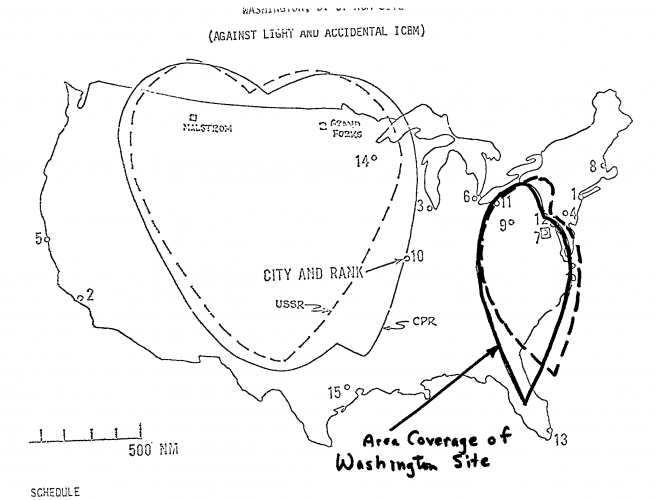
The Washington site will have no PAR of its own. This means that until other PARS, at Michigan/Ohio and New England, are available, its area coverage over the Northeastern Corridor toward New York will be very limited. It might reach Baltimore, but not Philadelphia. (The map at Tab A shows an approximation of the coverage of the lone Washington site. The Grand Forks PAR allows coverage out toward Lake Erie, while the MSR itself can track missiles which pass over Washington toward targets in the southeast.)
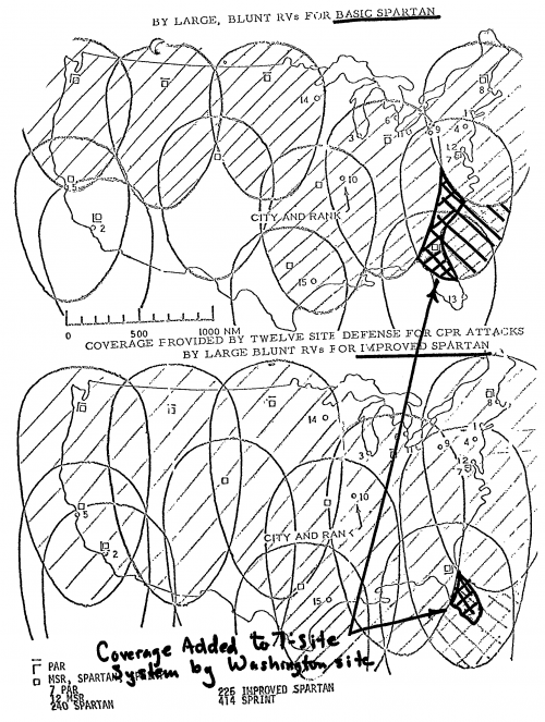
As shown in the map at Tab B, the Washington site makes a relatively modest contribution to coverage even after the full seven site "interim" system is complete, (The diagonals show the area protected by the seven site system. The cross-hatched area shows what would not be protected if the Washington site did not exist. ) On the other hand, once the New England and Michigan/Ohio sites are in place, the Washington site provides valuable redundant coverage and radar support for protecting the heavily populated Northeastern Corridor.
Some numbers from the diagrams:
---------------------------------
BASIC SPARTAN vs Large Blunt RVs (with PAR)
---------------------------------
780~ nautical miles wide by 1,000~ nautical miles high total footprint (662,400~ square nautical mile defended area), with the following dimensions:
250 nautical miles ahead of PAR/MSR
830 nautical miles below PAR/MSR
380 to 400 nautical miles to the side of the PAR/MSR
---------------------------------
IMPROVED SPARTAN vs Large Blunt RVs (with PAR)
---------------------------------
900~ nautical miles wide by 1,600~ nautical miles high total footprint (1.15~ million square nautical mile defended area), with the following dimensions:
300 nautical miles ahead of PAR/MSR
1,300 nautical miles below PAR/MSR
400 to 440 nautical miles to the side of the PAR/MSR