Flyaway

ACCESS: USAP
Senior Member
Joined
21 January 2015
Messages
10,601
Reaction score
12,146
New article from AW, including an image captioned 'This accurate model show the original KH-11 design that, like Hubble, carried about a 8-ft. mirror but with a shorter instrument base section.' Just looks like an image of Hubble to me & it would be a first for an image of it to be reproduced of it in public. Any thoughts on this?


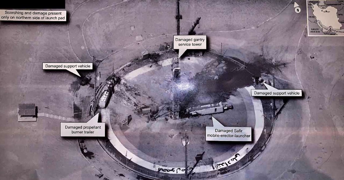
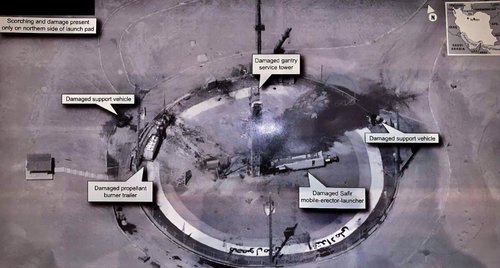
Also gets a mention in this with its official codename.

 
Flyaway said:
Just looks like an image of Hubble to me & it would be a first for an image of it to be reproduced of it in public. Any thoughts on this?

It is a retouched image of Hubble, not an image of KH-11.
 
The caption should say "This inaccurate model..."
 
blackstar said:
The caption should say "This inaccurate model..."

You have wonder why they decided to use the image combined with that caption.
 
Flyaway said:
blackstar said:
The caption should say "This inaccurate model..."

You have wonder why they decided to use the image combined with that caption.

I suspect they had an intern do the layout.
 
A vital part of the KH-11 history and another top article from Mr Day.

Yes that title is another Babylon 5 reference.

Shadow dancing: the Satellite Data System

by Dwayne A. Day
Monday, February 26, 2018

In the late 1960s, the CIA was researching technology as part of the ZAMAN program to develop a satellite with the capability to directly image the ground below and send that imagery electronically to a ground station. One issue facing ZAMAN’s designers was how to store the imagery on the satellite and to then transmit it. If the satellite could only transmit the images while in view of a ground station, this would dramatically limit how many images could be sent each day because the satellite would only be over a ground station for a limited amount of time. But there was a solution: instead of transmitting signals directly down to the ground, the imagery satellite could send them upward, to a communications relay satellite in a much higher orbit, and that satellite could relay the images to the ground. This approach added complexity, but provided numerous advantages, including increasing available transmission time.

 
ULA Delta IV-Heavy set to launch NROL-71

NROL-71 has proven one such mission. Before the launch time and hazard areas were published it was a safe bet that this launch would add a new member to the NRO’s fleet of KH-11, or Crystal, imaging satellites. Also formerly codenamed Kennen, Key Hole 11 (KH-11) spacecraft collect incredibly high-resolution images of the Earth’s surface and transmit them back to the ground for analysis. Originally developed in the 1970s, but upgraded over time, the KH-11 is among the largest satellites that the NRO operates and requires one of America’s most powerful rockets, the Delta IV Heavy, to place it into orbit.
 
USA 290 (NROL-71)

So, there is something new under the sun, in more than one way. While the general consensus still is that USA 290 is an electro-optical bird in the ADVANCED CRYSTAL lineage, the radical break with previous orbital structures for this series of satellites is highly interesting. It will be interesting to follow this new object, and see how things develop with future launches.
 
Speculated on NASA spaceflight forum this image is from a KH-11, probably USA 224.


The United States of America was not involved in the catastrophic accident during final launch preparations for the Safir SLV Launch at Semnan Launch Site One in Iran. I wish Iran best wishes and good luck in determining what happened at Site One.
 
Might as well put this recent article here.

The NRO is slow rolling implementation of DoD’s effort to to improve space operations safety by lifting restrictions on the location of classified satellites, insiders say.

“The US is being more transparent, but there are still those Cold Warriors that can’t figure out that things are changing and insist on subverting policy they have been tasked to implement,” one frustrated expert told me. “They are effectively taking USG efforts to be transparent and instead making it look like we’re playing games and can’t be trusted—basically shooting ourselves in the foot.”


I simulated the view from USA 224 (ADVANCED CRYSTAL optical reconnaissance satellite) towards the #Iranian launch platform. Simulation is for 09:44:23 UT when sat was at 43.97 deg elevation, azimuth 194.7 deg.

Simulation & real image compared:

@mhanham @trbrtc @nktpnd @cgbassa


Note that the sumulation features a satellite image that is not from the same time, hence difference in shadow directions. Relative positions of features matches.


I measured the semi-major and semi-minor axes of the ellipse (the obliguely viewed circular platform). The viewing angle is then derived by minor=major*cos(angle) --> so find the matching angle. That yielded nominal 43.97 deg. That value matches 09:44:23 UT and azimuth 194.7.


So the position of the satellite at 09:44:23 was taken, and in STK I let the viewq from the satellite point towards the launch platform. That yielded this. It is a very good match so there is no doubt in my mind that it is an image taken by USA 224.


This was the USA 224 satellite's position relative to the imaged launch site:


Note that the satellite orbit for USA 224 is based on amateur tracking data! Orbit used is the epoch 19239.00965638 orbit from McCants' classfd.tle file.

(there is an international group of dedicated 'amateur' observers, including me, that tracks these 'classified' objects)


Marco simulates the Safir launch pad image: infers it was taken by USA 244 at a slant range of 400 km. Looks to me like smallest round details are about 10 cm or so implying a resolution of 50 milliarcseconds.
 

Be advised that the projection goes as sin(elevation) = minor axis/major axis. At elevation 90 deg, both are the same and you get a circle.


F....

Luckily, that introduces only a 2-second error and 2-degree viewing angle difference. Updated view:


An error correction: two seconds difference in time of image, 0.15 deg in azimuth, 2 degrees in view angle.

09:44:20.7 UT, elevation 46.0, azimuth 194.85, range 384.5 km)
 
This blogpost consolidates two analysis which I initially published through Twitter. I will show in this analysis that there is very little doubt that USA 224 took this image.

(note: there is a black block in the upper left of the image that seems to be placed there to redact some information that might have been printed there. I think it is likely this information was the time of image, space platform ID and the location of the latter. It points out that some deliberate thought was given to the release of this image, before it was tweeted)

 
Last edited:
Yay! I have always subscribed to the maxim that sunlight is the best disinfectant, so I am happy as a clam that I am in complete agreement with the United States President Mister Donald John Trump with respect to publishing this picture.
 
Last edited:

Intersections in real time: the decision to build the KH-11 KENNEN reconnaissance satellite (part 1)

"On August 30, the US president released a remarkably detailed photograph of an Iranian rocket launch site. Very quickly, satellite spotters identified the American satellite that took it and numerous internet posts and news articles identified it as a “KH-11” satellite. That designation was discontinued decades ago, but the satellite is almost certainly a direct-line descendant of a satellite series that was first launched nearly 43 years ago and designated the KH-11 KENNEN. "
 
Intersections in real time: the decision to build the KH-11 KENNEN reconnaissance satellite (part 2)

In March 1969, President Richard Nixon canceled the HEXAGON satellite program in favor of the Manned Orbiting Laboratory (MOL) and its DORIAN camera system. By May 1969, influential intelligence advisor Edwin “Din” Land wrote Nixon recommending that he cancel MOL and continue development of a very high resolution camera that exploited DORIAN advances. Land also urged that most reconnaissance R&D be concentrated on near-real-time reconnaissance. He urged the President to start “highest priority” development of a “simple, long-life imaging satellite, using an array of photosensitive elements to convert the image to electrical signals for immediate transmission.” [1] CIA director Richard Helms also appealed to Nixon on behalf of HEXAGON, and Nixon reinstated the program. A few months later Nixon canceled MOL/DORIAN. The next three years proved to be a turbulent time of debate over the development of a near-real-time reconnaissance satellite, with the technology slowly advancing while senior intelligence officials disagreed about the best way to get reconnaissance photos back faster.

 
Late last month, President Donald Trump tweeted from his iPhone an image captured by a classified spy satellite of an Iranian launchpad damaged the day before by a space launch attempt gone astray.


“The United States of America was not involved in the catastrophic accident during final launch preparations for the Safir SLV Launch at Semnan Launch Site One in Iran,” Trump tweeted Aug. 30, not long after his daily intelligence briefing. “I wish Iran best wishes and good luck in determining what happened at Site One.”

 
Hi,

I just used - for testing - an AI-software to enhance image size (resolution).
There are different upscaling modes. I only used x4 but x16 is possible.
AI software used: letsenhance.io
It reconstructs details.

A.

PS) I used Trump's original posted image, characterized by Twitter's natively-built heavy compression.
 

Attachments

  • EDPFB_XWkAY6QWB_upscaled_image_x4.jpg
    EDPFB_XWkAY6QWB_upscaled_image_x4.jpg
    3.9 MB · Views: 81
Last edited:
Update on the above.


From: Nico Janssen via Seesat-l <seesat-l_at_satobs.org>

Date: Wed, 29 Jan 2020 14:18:29 +0100

Kosmos 2543 is still in its 588 x 861 km orbit. But meanwhile Kosmos 2542 raised its orbit to a 369 x 915 km orbit. USA 245 is now in a 283 x 1002 km orbit. The orbit planes of Kosmos 2542 and USA 245 are about 0.55 degrees apart and the difference between their orbital periods is only 1 second.
 
I have this growing suspicion the Soviets, pardon, the Russians, always wanted to shoot down those freakkin' NRO satellites that since 1962 have replaced the U-2s to spy them.
 
Further update on Seesat to the above:


From: Michael R Thompson via Seesat-l <seesat-l_at_satobs.org>

Date: Thu, 30 Jan 2020 05:31:48 +0000

Took a deeper look tonight.

I can't find any Russian satellites that are as closely sync'd as USA 245.

If you want to be very generous, there are Russian satellites in a similar plane that yield marginal passes (~500km) every few days:


* Cosmos 2523: A previous inspection satellite from 2017

* Resurs P1: An earth observation satellite. There's a very close pass on Jan 30 (100km), but the rest are in the 500km range every ~2 days.

Additionally, the first maneuver on January 21st was perfectly sync'd with the closest approach of Cosmos 2542 and USA 245, which before this set of maneuvers, were occurring every 11 days.

With continuous visibility from a trailing distance of 100-500km, and a low required slew rate (consistently less than 0.1 deg/s) observation would be quite possible.


Dare I say likely?
 
Be interesting to see if over time the other 3 KH-11s gain their own watchers. Perhaps in the event of war they’d become more than watchers.
 
Maybe that's one reason US wants Refuelling capability for Satellite... Use fuel to maneuver away from the Snooper... then refuel so the satellite can keep operating.
 
13 years since they killed Misty follow-ons. Wonder what the AoA looks like now.
 
Nothing new under the sun - read Red storm rising again !! A KH-9 (Big Bird) was stalked (and killed) by an ASAT weapon.
 
I’ve seen it suggested that the idea is to make the KH-11 keep manoeuvring, and therefore use up its limited propellant supply. As a result reducing its Orbital lifetime.
 
I would not be surprised if Russia releases a photo of the KH-11 soon to let the world and the US know it is the first to reconnoiter a satellite via rendezvous. Considering the Russians have increased their intercepts of aircraft in international airspace and ships on the high seas in the last few years, they may simply be sending a message to the US to let them know that Russia is still a force to be reckoned with.
 
I’ve seen it suggested that the idea is to make the KH-11 keep manoeuvring, and therefore use up its limited propellant supply. As a result reducing its Orbital lifetime.
This is almost certainly one of the goals, though the direct reconnaissance value of a close approach/inspection shouldn't be discounted. Not to mention, gathering data on how fast NRO is to move a Keyhole when it is being stalked and how much juice they put into each burn.
 

Similar threads

Back
Top Bottom