DEVELOPMENT, PRODUCTION, AND DEPLOYMENT OF THE NlKE AJAX GUIDED MISSILE SYSTEM
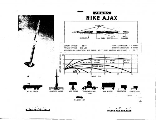
While reading through the above document, I came across this chart, which I presume to be a chart of intercept envelope. Why would the first line simply stop as abruptly as it does at the 15km mark? A typographic error? Also, why is the altitude as low as it is? Test shots reached to 140,000 feet and other sources indicate the envelope extended up to 60,000 feet. Is that just a difference between development goal and actual capability or something else?
While reading through the above document, I came across this chart, which I presume to be a chart of intercept envelope. Why would the first line simply stop as abruptly as it does at the 15km mark? A typographic error? Also, why is the altitude as low as it is? Test shots reached to 140,000 feet and other sources indicate the envelope extended up to 60,000 feet. Is that just a difference between development goal and actual capability or something else?