
You are using an out of date browser. It may not display this or other websites correctly.
You should upgrade or use an alternative browser.
You should upgrade or use an alternative browser.
DARPA Blackjack
- Thread starter bobbymike
- Start date
- Joined
- 21 April 2009
- Messages
- 14,203
- Reaction score
- 9,057
Re: DARPA Blackjack plus Pitboss
DARPA solicits proposals for Blackjack's Pit Boss technology
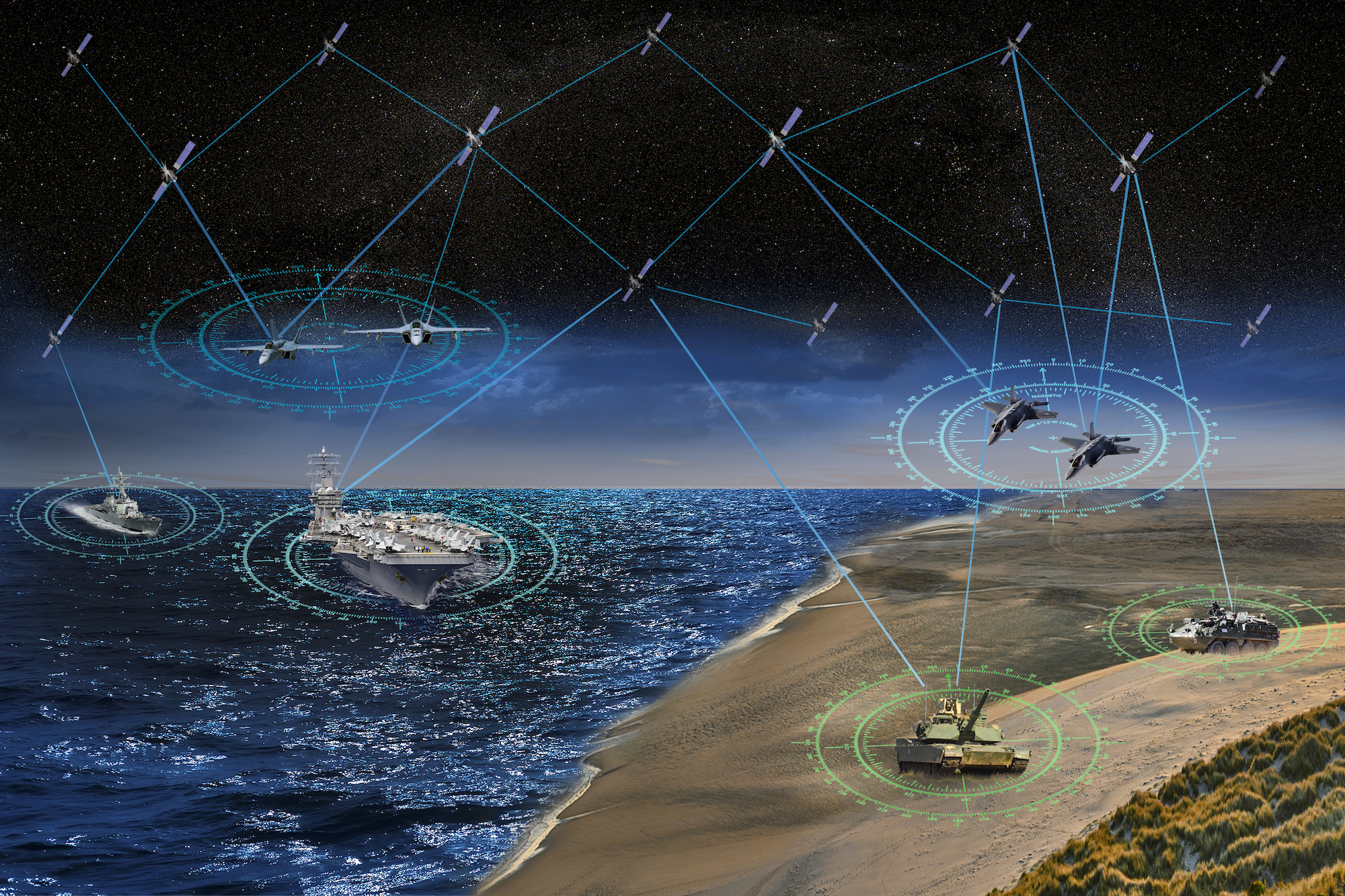
The Defense Advanced Research Projects Agency is calling for industry input into a software development effort known as Pit Boss, which will demonstrate space-based autonomous command-and-control and data processing to support the agency's highly watched Blackjack program.
DARPA solicits proposals for Blackjack's Pit Boss technology
The Defense Advanced Research Projects Agency is calling for industry input into a software development effort known as Pit Boss, which will demonstrate space-based autonomous command-and-control and data processing to support the agency's highly watched Blackjack program.
- Joined
- 21 April 2009
- Messages
- 14,203
- Reaction score
- 9,057

Here are the companies building the brains behind DARPA's Project Blackjack
Pit Boss is an autonomous mission management system being built for Project Blackjack, a DARPA initiative to demonstrate the value of a large proliferated constellation of low earth orbit satellites for a variety of military uses.
 www.c4isrnet.com
- Joined
- 21 April 2009
- Messages
- 14,203
- Reaction score
- 9,057

Lockheed Martin wins DARPA contract to integrate Blackjack satellites
Lockheed Martin wins DARPA contract to integrate Blackjack satellites
 spacenews.com
Grey Havoc
ACCESS: USAP
- Joined
- 9 October 2009
- Messages
- 24,413
- Reaction score
- 17,872
How Project Blackjack is turning the corner
DARPA's Project Blackjack will demonstrate how an on orbit mesh network can help the military. In an interview with C4ISRNET, Project Manager Paul “Rusty” Thomas explains the path forward for the experimental constellation.
www.c4isrnet.com
Would it be possible to develop the same concept for GPS satellites?
That's what the UK is trying to do with OneWeb, since they got cutoff from Galileo.
jsport
what do you know about surfing Major? you're from-
- Joined
- 27 July 2011
- Messages
- 8,118
- Reaction score
- 6,393

Senate NDAA Mandates NRO To 'Maximize' Commercial Imagery Use - Breaking Defense
"This language from the SASC serves notice that they intend to keep a close eye on the NRO’s commercial remote sensing program," observed Keith Masback, a former senior defense and intelligence official.
KJ_Lesnick
ACCESS: Top Secret
- Joined
- 13 February 2008
- Messages
- 1,042
- Reaction score
- 123
Well, just don't give it control of nuclear weapons or you'll have Skynet from Terminator!
J/k
J/k
aonestudio
I really should change my personal text
- Joined
- 11 March 2018
- Messages
- 3,323
- Reaction score
- 8,956
Northrop Grumman to supply navigation payloads for DARPA’s Blackjack satellites
Northrop Grumman to supply navigation payloads for DARPA’s Blackjack satellites
spacenews.com
- Joined
- 21 April 2009
- Messages
- 14,203
- Reaction score
- 9,057

Exclusive: DARPA 'Likely' To Demo Only 2 Blackjack Payloads - Breaking Defense
"We really focused on payloads that had tactical utility, because they were an underserved market," said Blackjack program manager Stephen Forbes.
aonestudio
I really should change my personal text
- Joined
- 11 March 2018
- Messages
- 3,323
- Reaction score
- 8,956
View: https://twitter.com/DARPA/status/1412802776191705089
DARPA successfully deployed two satellites on June 30 as part of the SpaceX Transporter 2 launch. Both Mandrake 2 spacecraft, Able and Baker, are functioning well and progressing through checkout and commissioning. Conceived as an early risk-reduction flight for DARPA’s Blackjack program, the Mandrake 2 mission will prove out advanced laser communications technologies for a broad government stakeholder team that includes DARPA, Space Development Agency (SDA), Air Force Research Laboratory Space Vehicles Directorate (AFRL/RV), and Office of the Secretary of Defense’s (OSD) Joint Capability Technology Demonstration (JCTD) office.
During its on-orbit mission, Mandrake 2 will demonstrate the viability of low size, weight, power, and cost laser communications terminals that are interoperable. “This constitutes a game-changing advancement and a critical enabler for proliferated space architectures,” said Stephen Forbes who is program manager of the Blackjack program in DARPA’s Tactical Technology Office. “Mandrake 2 has already successfully demonstrated a rapid satellite development timeline, since the Blackjack program moved from contract award to delivery of space vehicles at the launch site in less than nine months.”
Grey Havoc
ACCESS: USAP
- Joined
- 9 October 2009
- Messages
- 24,413
- Reaction score
- 17,872
The company is currently providing its optical cross-link terminals for DARPA’s Blackjack program, which seeks to prove the viability of a proliferated small satellite constellation in low Earth orbit. Mynaric also worked with other cross-link providers as well as the Space Development Agency to develop an interoperability standard to ensure laser cross-links on the U.S. military’s small satellites can communicate effectively with commercial constellations in development by Amazon, SpaceX, OneWeb, Telesat and more.

The German ‘new space’ industry is booming. So why isn’t Berlin buying in?
The government has articulated the importance of space, but has yet to put many actual euros behind the statement, according to analysts.www.defensenews.com
jsport
what do you know about surfing Major? you're from-
- Joined
- 27 July 2011
- Messages
- 8,118
- Reaction score
- 6,393
SEAKR moving forward with DARPA’s Pit Boss project
The company says DARPA has selected it as the sole prime for an autonomous mission management solution for Project Blackjack.
www.c4isrnet.com
jsport
what do you know about surfing Major? you're from-
- Joined
- 27 July 2011
- Messages
- 8,118
- Reaction score
- 6,393
Raytheon completes purchase of Blue Canyon Technologies
The company's customers for small satellites include the U.S. Space Force, Air Force and DARPA.
www.c4isrnet.com
DARPA seeking satellite laser terminals that can talk to any space network
DARPA seeking satellite laser terminals that can talk to any space network
spacenews.com
- Joined
- 21 April 2009
- Messages
- 14,203
- Reaction score
- 9,057
Classified Space Programs Poised for Budget Boost
Classified Space Programs Poised for Budget Boost
jsport
what do you know about surfing Major? you're from-
- Joined
- 27 July 2011
- Messages
- 8,118
- Reaction score
- 6,393

A new constellation? Space Force wants to get into tactical satellite imagery business
While plans aren't set, the Department of Defense is considering building out a new constellation of imagery satellites for tactical use.
www.c4isrnet.com
jsport
what do you know about surfing Major? you're from-
- Joined
- 27 July 2011
- Messages
- 8,118
- Reaction score
- 6,393

Army to work with satellite radar imagery provider ICEYE
Because SAR isn’t dependent on visibility, it can be used to produce imagery at any time of day or night and through cloud cover.
www.c4isrnet.com
jsport
what do you know about surfing Major? you're from-
- Joined
- 27 July 2011
- Messages
- 8,118
- Reaction score
- 6,393

Is Project Blackjack still relevant?
Project Blackjack was intended to demonstrate the value of a proliferated satellite constellation made up of dozens of satellites in low Earth orbit, but the Pentagon has since bought into the concept and begun investing in an operational alternative.
www.c4isrnet.com
- Joined
- 26 September 2008
- Messages
- 2,135
- Reaction score
- 1,333
Is Project Blackjack still relevant?
Project Blackjack was intended to demonstrate the value of a proliferated satellite constellation made up of dozens of satellites in low Earth orbit, but the Pentagon has since bought into the concept and begun investing in an operational alternative.
If you look at the history of DARPA space projects, they don't have a very good track record. A lot of their technologies go nowhere, or they don't finish the project. I don't know why that is. I heard from somebody years ago that for one of their major projects (the refueling/servicing satellite) they did a bad job of listening to the potential user, the Air Force. The result was that they produced something that the user was not interested in and that's why a decade later we still don't have a servicing satellite for the military.
jsport
what do you know about surfing Major? you're from-
- Joined
- 27 July 2011
- Messages
- 8,118
- Reaction score
- 6,393
As Satellite Images Reshape Conflict, Worries Mount About Keeping Them Safe
Radio data collected from space is the next frontier.
 www.defenseone.com
Frazier highlighted work that Maxar has been doing with the Army’s 82nd Airborne, as part of their Scarlet Dragon events, which occur every 90 to 100 days. Over the past 18 months, he said, they learned how to move images to troops on the battlefield in one-tenth of the time.
The company is also putting up more satellites, which “is going to allow us to continue to collect imagery at very high resolution, so 30 to 50-centimeter resolution, but then also be able to dramatically increase revisit over areas of the world that matter.” Over the mid-latitudes, the region between the tropics and the polar circles that includes much of Asia, “We'll have the ability to collect up to 15 times a day and then also be able to interweave that with other sources to just get persistence.”
In the years ahead, expect an explosion in other kinds of satellite-gathered data—for example, unencrypted radio chatter from military units that are broadcasting their location via global positioning. At the conference, Annie Glassie, a mission analyst with HawkEye 360, a satellite company that specializes in gathering radio signals, showed how her firm could identify ships that had turned off their AIS receiver— in effect, trying to go dark.
Kari A. Bingen, HawkEye 360’s chief strategy officer, said, “What we are able to detect is effectively.. those electronic warfare, those indicators, emitters, jamming GPS radars, other things that are a leading indicator of, frankly, where Russia forces are and where they're moving.”
But some officials and representatives from industry are increasingly worried that commercial intelligence satellites will soon become key targets for adversaries who want to return to the days when the world couldn’t easily track their military formations.
“Both Chinese and Russian military doctrine now capture their view of space as critical to modern warfare. And they consider the use of space and counter space capabilities as a means of reducing U.S. military effectiveness and for winning future wars,” said Lt. Gen. Chance Saltzman, the chief operations officer for the U.S. Space Force. “We've seen destructive debris generated by anti-satellite missile tests, [radio-frequency] interference, cyber attacks on terrestrial space nodes and provocative on-orbit anti-satellite demonstrations, such as firing projectiles.”
Last edited:
jsport
what do you know about surfing Major? you're from-
- Joined
- 27 July 2011
- Messages
- 8,118
- Reaction score
- 6,393

ATLAS Space: A 'Netflix' for satellite ground operations software - Breaking Defense
"We are a ground software service provider," ATLAS Space co-founder Mike Carey told Breaking Defense. "We've come up with a very modern, cloud-based, scalable secure platform by which any number of antennas can be brought in."
jsport
what do you know about surfing Major? you're from-
- Joined
- 27 July 2011
- Messages
- 8,118
- Reaction score
- 6,393

Project Blackjack: DARPA's test of satellite laser links delayed - Breaking Defense
A DARPA official couldn't confirm an exact launch date for the two Telesat birds, but explained in an email today that the agency is awaiting on a launch slot as well as the availability of an integration facility.
jsport
what do you know about surfing Major? you're from-
- Joined
- 27 July 2011
- Messages
- 8,118
- Reaction score
- 6,393
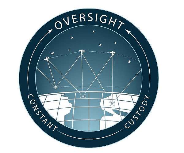
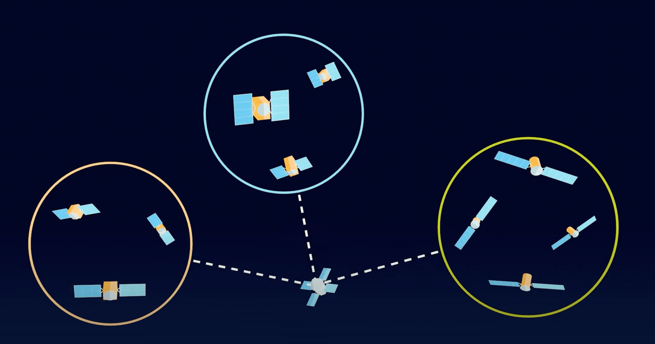
Oversight Program aims to make space domain more tactically relevant for military planners, warfighters
Washington DC (SPX) Mar 21, 2023 - DARPA aims to help military planners keep track of up to 1,000 targets of interest through management of available space domain resources. The goal of the Oversight program is to enable constant cus
www.spacewar.com
Forest Green
ACCESS: USAP
- Joined
- 11 June 2019
- Messages
- 12,780
- Reaction score
- 27,504

Beyond Blackjack: DARPA planning new X-plane to give ship COs local ISR assets - Breaking Defense
The program manager told Breaking Defense all six companies remaining in the program are narrowing in on a similar design incorporating folding wings.
Scott Kenny
ACCESS: USAP
- Joined
- 15 May 2023
- Messages
- 16,977
- Reaction score
- 24,081
How long has this project been going, for the A and B satellites to be named Able and Baker instead of the international Alpha and Bravo?!?View: https://twitter.com/DARPA/status/1412802776191705089
DARPA successfully deployed two satellites on June 30 as part of the SpaceX Transporter 2 launch. Both Mandrake 2 spacecraft, Able and Baker, are functioning well and progressing through checkout and commissioning. Conceived as an early risk-reduction flight for DARPA’s Blackjack program, the Mandrake 2 mission will prove out advanced laser communications technologies for a broad government stakeholder team that includes DARPA, Space Development Agency (SDA), Air Force Research Laboratory Space Vehicles Directorate (AFRL/RV), and Office of the Secretary of Defense’s (OSD) Joint Capability Technology Demonstration (JCTD) office.
During its on-orbit mission, Mandrake 2 will demonstrate the viability of low size, weight, power, and cost laser communications terminals that are interoperable. “This constitutes a game-changing advancement and a critical enabler for proliferated space architectures,” said Stephen Forbes who is program manager of the Blackjack program in DARPA’s Tactical Technology Office. “Mandrake 2 has already successfully demonstrated a rapid satellite development timeline, since the Blackjack program moved from contract award to delivery of space vehicles at the launch site in less than nine months.”
Similar threads
-
 DARPA to Transfer Advanced Space Debris Telescope to Air Force
- Started by Flyaway
- Replies: 6
-

-
-
DARPA moving forward with development of nuclear powered spacecraft
- Started by Flyaway
- Replies: 33
-
DARPA to develop microscale navigational gyro for guided munitions and hand-held
- Started by seruriermarshal
- Replies: 1