SR-71 Anti-Submarine Capability

World B4

my bad y'all
Joined
25 June 2017
Messages
594
Reaction score
558
https://theaviationgeekclub.com/the...r-system-to-photograph-soviet-submarines/amp/The article summarizes a flight of an SR-71 equipped with the ASARS-1 synthetic aperture radar, and its use in monitoring the Soviet Northern Fleet's submarines, and I'd like to know more. Was the radar capable of picking up subsurface targets, or just docked boats? Were the Mildenhall SR-71s primarily asw recon aircraft? Were the mission and its sequels primarily focused on locating the whole Northern Fleet, the submarine assets, or the ssbns specifically?
 
https://theaviationgeekclub.com/the...r-system-to-photograph-soviet-submarines/amp/The article summarizes a flight of an SR-71 equipped with the ASARS-1 synthetic aperture radar, and its use in monitoring the Soviet Northern Fleet's submarines, and I'd like to know more. Was the radar capable of picking up subsurface targets, or just docked boats? Were the Mildenhall SR-71s primarily asw recon aircraft? Were the mission and its sequels primarily focused on locating the whole Northern Fleet, the submarine assets, or the ssbns specifically?
I don't think SARs could penetrate sea water, as water would absorb and/or reflect microwave which makes it impossible to observe what's actually underwater. So likely would just be overflying submarine facilities and maybe could potentially image surfaced boats.
 
Probably to pick up snorkels or periscopes sticking out of the water surface .....
 
Probably to pick up snorkels or periscopes sticking out of the water surface .....
The SR-71 is probably the worst platform for slow, persistent reconnaissance ever built. That being said is why it was retired, and why there was no successor.
 
Playing in Google found similar article with different title dated September 1, 2024
I have no idea what if any significance to assign to that.

https://theaviationgeekclub.com/the...radar-system-to-photograph-soviet-submarines/
so, we have 2024's,
The unknown story of SR-71 #955: the first Blackbird to use the Advanced Synthetic Aperture Radar System to photograph Soviet Submarines
By Linda Sheffield Miller
Sep 1 2024

In this article:

The Blackbird
SR-71 #955
Regenerating the SR-71 program

and this thread's article that the web page seems to not be displaying a date and author for,
The secret life of SR-71 #955: the first Blackbird to use the Advanced Synthetic Aperture Radar System to photograph Soviet Submarines
SR-71 #955 was a test bird destined to spend her flying career in the US, primarily in Southern California. But this Blackbird had a secret life.
 
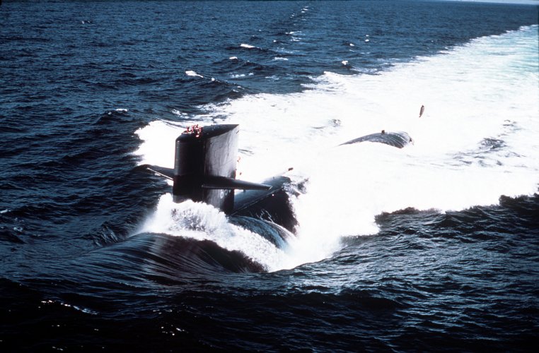
When a submarine moves underwater, it creates a disturbance on the surface that can be detected by very sensitive instruments. The difference in the height of the wave created by the displacement with respect to normal sea level can be measured, which is not normally visible but is statistically visible after processing the data by computer. Submarines leave behind a trail of warm water that rises to the surface and can be detected by infrared sensors, they also generate bioluminescence by altering the plankton.

https://user.eumetsat.int/resources/case-studies/ship-trails-and-industrial-plumes
https://www.abc.net.au/news/science...rine-internal-waves-what-do-we-know/100107196
 

Attachments

  • 853.jpg
    853.jpg
    5.8 MB · Views: 16
  • USS_Ray_(SSN-653).jpg
    USS_Ray_(SSN-653).jpg
    1.5 MB · Views: 14
Last edited:
I'd be very confident that they were using ASARS to image the subs in harbor so they could see which ones were at sea. They used oblique photo imagery to do that as well, but ASARS might have been better at it.
 
Well…perhaps moving across quite a distance allows for more of a wake to be seen?

Maybe speed and altitude can help after all…
 
Well…perhaps moving across quite a distance allows for more of a wake to be seen?

Maybe speed and altitude can help after all…

Kelvin wake imaging remains only theoretically feasible, despite a lot of papers out of China.
 
Besides it takes time for the signs to show up on the surface. The search area could be a dozen miles in size. Let alone by the time a unit reaches the area to engage
The best use is to let you know with more certainty how many there are. And using that knowledge to judge the enemy's possible intentions and moves. And lets you deploy your resources less "wasteful".
 
Back
Top Bottom