Threat geolocation - SEAD/DEAD

Ronny

ACCESS: Top Secret
Joined
19 July 2019
Messages
1,024
Reaction score
904
.From what we know, a single F-35 can locate ground radar faster than 3 F-16CJ working together. But how fast can 3 F-16CJ working together find a radar? are they faster than RC-135 working alone? If 3 F-16CJ can triangulate threat faster than a single RC-135, that means F-35 can geolocate even faster than RC-135?. By contrast, if 3 F-16 are slower than a single RC-135, that means it will take them more than 20-30 minutes to geolocate radar with AN/ASQ-213?
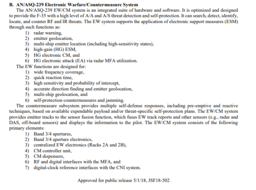
ASQ-239.PNG
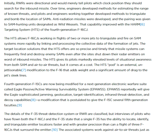
AE93E708-E4A7-4638-AD9C-B6084F967430.jpeg
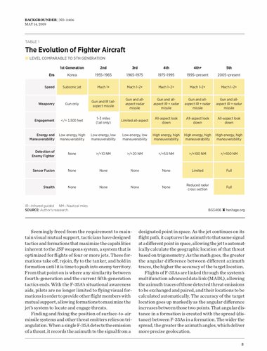
heritage report.PNG
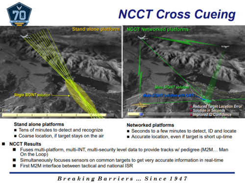
rc-135.PNG
 
spying for something and secrets for free (Dire Straits)
 
Low energy, low maneuverability 3 gen jets... That's quite interesting.
 
Low energy, low maneuverability 3 gen jets... That's quite interesting.
RC-135 is a SIGINT aircraft, it isn't a fighter, so it isn't meant to be maneuverable and high energy because you prefer bigger space for equipment. It supposed to skirt at extended distance from the battlefield.You see, Russia also use very low energy, low maneuverability aircraft such as II-20, Tu-214R for SIGINT
 
RC-135 is a SIGINT aircraft, it isn't a fighter, so it isn't meant to be maneuverable and high energy because you prefer bigger space for equipment. It supposed to skirt at extended distance from the battlefield.You see, Russia also use very low energy, low maneuverability aircraft such as II-20, Tu-214R for SIGINT
Was pointing at graph in article, not RC-135 specifically.
 
.From what we know, a single F-35 can locate ground radar faster than 3 F-16CJ working together. But how fast can 3 F-16CJ working together find a radar? are they faster than RC-135 working alone? If 3 F-16CJ can triangulate threat faster than a single RC-135, that means F-35 can geolocate even faster than RC-135?. By contrast, if 3 F-16 are slower than a single RC-135, that means it will take them more than 20-30 minutes to geolocate radar with AN/ASQ-213?

FWIW- My impression is that the RC-135 RJ takes longer because its a standoff platform and would have to rely on single ship triangulation for range information. I would be surprised if a flight of F-16CJs is not faster at emitter geolocation as multi-ship triangulation should be pretty quick and more effective than single-ship triangulation. Even if the RJ has larger more sensitive receivers. I recall that when the F-22 was introduced it was lauded as being better than the RJ; this was in part because it could operate closer to the threat and also at high altitudes which facilitates single ship triangulation via trigonometric solutions. This was before increment 3 upgrades which apparently have significantly enhanced this ability. The F-35 is undoubtedly as good and potentially superior to the F-22. Part of this ability for these 5th gen jets is, however, is tied into the AESA ground search and targeting modes which can precisely pinpoint the emitter sites once its been located by the ES suite.
 
I doubt anyone who knows will answer. But several aircraft with a datalink can geolocate by differential time of arrival fairly readly; we don't need to know any special secret squirrel stuff for that. The issue is, can you detect the emission and can you share that data across at least two other frames of reference to establish location? In the case of something like an EF-18 or F-35, I think the answer is probably yes. My understanding is that the RC-135 for the most part handles detection and characterization, not tactical location and engagement. So comparing it with fighter types is not equivalent. F-16CJ and F-18G/F-35 is a fair comparison IMO.
 
.From what we know, a single F-35 can locate ground radar faster than 3 F-16CJ working together. But how fast can 3 F-16CJ working together find a radar? are they faster than RC-135 working alone? If 3 F-16CJ can triangulate threat faster than a single RC-135, that means F-35 can geolocate even faster than RC-135?. By contrast, if 3 F-16 are slower than a single RC-135, that means it will take them more than 20-30 minutes to geolocate radar with AN/ASQ-213?

View attachment 631133
I don't know how F-35 geolocate emitter so fast but two or three F-16 will geolocate target much faster and more accurate than a singular RC-135VW. Because multiship emitter geolocation on F-16 rely on TDOA/FDOA between multiple aircraft.
The HTS pod features a passive digital receiver that cues the HARM against SAM radars.
In 2008, the USAF finalized the upgrade of all HTS pods to Release 7+ (R7+), which
incorporates a GPS receiver and redesigned software to precisely geo-locate radar emissions.
This capability, known as precision targeting or “PT ranging”, uses cooperative multi-aircraft targeting algorithms to network the HTS pods on multiple F-16s to exchange time and frequency difference of arrival (TDOA/FDOA) information on threat emissions. With information from multiple HTS pods, F-16s can triangulate the precise location of an emitter.
 
I don't know how F-35 geolocate emitter so fast but two or three F-16 will geolocate target much faster and more accurate than a singular RC-135VW. Because multiship emitter geolocation on F-16 rely on TDOA/FDOA between multiple aircraft.

I mean, there are ways for a single craft to generate bearings to emitters. Put receivers on each wingtip of an F-35 and you get a 35ft separation to use for triangulation.
 
Put receivers on each wingtip of an F-35 and you get a 35ft separation to use for triangulation.
To be fair though, radar receiver aren't really that accurate. Receiver with interferometer can achieve accuracy within 0.5-1 degree. However, if we use wing tip as reference point for triangulation, assuming the target is at 100 km away, we will need to drag a triangle with angle of 0.005 degrees. That is several order of magnitude more accurate than what the radar and ESM system can achieve.
 
Last edited:
To be fair though, radar receiver aren't really that accurate. Receiver with interferometer can achieve accuracy within 0.5-1 degree. However, if we use wing tip as reference point for triangulation, assuming the target is at 100 km away, we will need to drag a triangle with angle of 0.005 degrees. That is several order of magnitude more accurate than what the radar and ESM system can achieve.
Yup!

You can also use either the emitter's motion (SAR) or the tracker's motion (ISAR). Or all of the above at once, if you have the computing horsepower.
 
There are radar receivers that can give you directional information with regards to an emitter, but as someone pointed out, it isn’t a precise location. It would give you a small patch of ground you can focus other sensors on.

Differential time of arrival is much more precise; I think it would allow weapon delivery. But it requires three datalinked platforms all receiving the same pulse. I suspect F-35 can use both methods of location.
 
Last edited:
Yup!

You can also use either the emitter's motion (SAR) or the tracker's motion (ISAR). Or all of the above at once, if you have the computing horsepower.
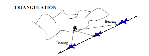
you can use the aircraft motion to generate several line of bearing to target, then compute a triangulation solution from that.
However, I honestly don't see how can that be faster than multi ship TDOA that 3 F-16 do.
What curious here is that: for some strange reason, a single F-35 can geolocate emitter faster than 3 F-16, it doesn't make sense
single-ship-triangulation.png
 
There are radar receivers that can give you directional information with regards to an emitter, but as someone pointed out, it isn’t a precise location. It would give you a small patch of ground you can focus other sensors on.

Differential time of arrival is much more precise; I think it would allow weapon delivery. But it requires three datalinked platforms all recirculating the same pulse. I suspect F-35 can use both methods of location.
Yep, F-35 can use both single ship kinematic triangulation and multi ship TDOA multilateration
But the curious part is that F-35 pilot claimed that a single F-35 can geolocate thread quicker than 3 datalinked F-16
That very strange
 
There are radar receivers that can give you directional information with regards to an emitter, but as someone pointed out, it isn’t a precise location. It would give you a small patch of ground you can focus other sensors on.

Differential time of arrival is much more precise; I think it would allow weapon delivery. But it requires three datalinked platforms all recirculating the same pulse. I suspect F-35 can use both methods of location.
Would be shocked if it couldn't.
 
fun fact, F-35 ESM sensor can only detect the azimuth of target, and not the elevation
If it's a ground radar frequency, you don't need the elevation. Get 2-3 azimuth readings and you'll know where it is. (two to locate, third to check)
 
If it's a ground radar frequency, you don't need the elevation. Get 2-3 azimuth readings and you'll know where it is. (two to locate, third to check)
Low frequency doesn't necessary mean ground, high frequency doesn't necessary mean airborne target though
For example: type 055 destroyer use X-band radar, E-2 sentry use UHF radar
Normally, knowing only azimuth, you will need ten minutes to geolocate long range emitter by line of bearing. But if you also know elevation, you can triangulate the emitter location instantly because 1 edge of the triangle (which is aircraft altitude) is already known
 
Last edited:
Low frequency doesn't necessary mean ground, high frequency doesn't necessary mean airborne target though
For example: type 055 destroyer use X-band radar, E-2 sentry use UHF radar
Normally, knowing only azimuth, you will need ten minutes to geolocate long range emitter by line of bearing. But if you also know elevation, you can triangulate the emitter location instantly because 1 edge of the triangle (which is aircraft altitude) is already known
It's also a lot harder to set up a radar receiver to give you azimuth+elevation.
 
It's also a lot harder to set up a radar receiver to give you azimuth+elevation.
Receiver for azimuth can be on the wing leading edge, receiver for elevation can be on vertical tail, honestly not sure why they didn’t do that
 
Back
Top Bottom