
You are using an out of date browser. It may not display this or other websites correctly.
You should upgrade or use an alternative browser.
You should upgrade or use an alternative browser.
SpaceX
- Thread starter FutureSpaceTourist
- Start date
Scott Manley has just uploaded a video about Starship SN40's epic sea-voyage:
Starship SN40 has finally made it out of the middle of the Indian ocean, being towed to Christmas Island by the Normand Ranger and Go Australis. It's not being brough ashore, there now a specialized semi-submersible vessel 'Forte' which includes a deck that can go under the water, allowing cargo to be floated over the top to simplify loading.
Forte could in theory take it all the way to the US, andthat would take almost 2 months. Or it might take it to Australia and then load it onto a smaller ship for the trip to the US. We don't know right now, but we'll find out.

- Joined
- 13 August 2007
- Messages
- 10,462
- Reaction score
- 18,229
- Joined
- 13 August 2007
- Messages
- 10,462
- Reaction score
- 18,229
SpaceX launch support crews seem to have an almost spooky ability to assemble parts into components and components into things at an impressive speed. Their vaunted "vertical integration"?
It is not "launch support". It is construction.SpaceX launch support crews seem to have an almost spooky ability to assemble parts into components and components into things at an impressive speed. Their vaunted "vertical integration"?

- Joined
- 3 June 2011
- Messages
- 21,073
- Reaction score
- 19,479
I wonder how much of it is contracted out vs in-house.It is not "launch support". It is construction.
- Joined
- 13 August 2007
- Messages
- 10,462
- Reaction score
- 18,229
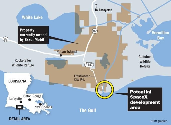
The Trump Administration is pushing for deregulation on Superheavy Launch sites
one of first is SpaceX with Starbase Louisiana
View: https://twitter.com/elonmusk/status/2092292773915537580

one of first is SpaceX with Starbase Louisiana
View: https://twitter.com/elonmusk/status/2092292773915537580

- Joined
- 13 August 2007
- Messages
- 10,462
- Reaction score
- 18,229
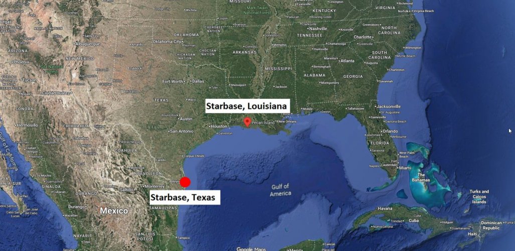
Starbase Texas - Two Pads - Lox production installed, Methane production planned
Starbase Florida -Three Pads - using NASA and USSF infrastructure
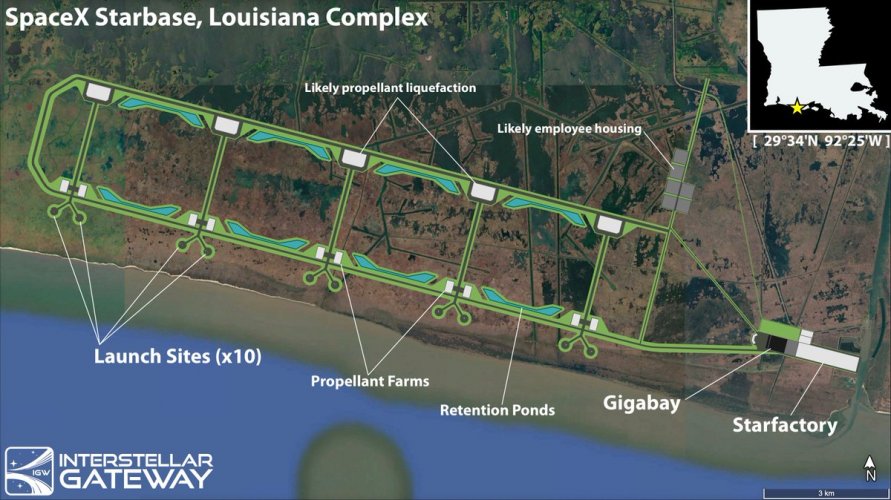
Starbase Louisiana - TWELF pads planned - local Lox & Methane production planned
SpaceX manage with Three launch pads for Falcon 9 up to 165 launches in 2025.
What they manage with 17 launch pads for Starship ?
Under conservative estimation: 935 launches per year...
Starbase Florida -Three Pads - using NASA and USSF infrastructure
Starbase Louisiana - TWELF pads planned - local Lox & Methane production planned
SpaceX manage with Three launch pads for Falcon 9 up to 165 launches in 2025.
What they manage with 17 launch pads for Starship ?
Under conservative estimation: 935 launches per year...
- Joined
- 3 June 2011
- Messages
- 21,073
- Reaction score
- 19,479
martinbayer
ACCESS: Above Top Secret
- Joined
- 6 January 2009
- Messages
- 5,081
- Reaction score
- 7,004
Oh no - no egomaniac online new posts! How will global humanity ever survive???SpaceX is systematic remove posting on X
About close up photo of Starship 40 and other information like HLS design
Same goes for TESLA about Optimus robots and AI Centers

Forest Green
ACCESS: USAP
- Joined
- 11 June 2019
- Messages
- 14,714
- Reaction score
- 31,979
- Joined
- 13 August 2007
- Messages
- 10,462
- Reaction score
- 18,229
The Transporter for StarSHIP 40 has arrive
View: https://twitter.com/BindiBush/status/2092472763055518025
View: https://twitter.com/BindiBush/status/2092472763055518025
The Transporter for StarSHIP 40 has arrive
View: https://twitter.com/BindiBush/status/2092472763055518025
That's exactly what I was expecting for getting the test-vehicle back to the USA.
After SpaceX engineers have finished examine it I wonder if it will end up in a museum?
There is no NASA and USSF LOX or Methane infrastructure at the Cape. LOX is commercially produced in Mims, FL and Methane is trucked in. They are trying to find a location for liquefaction plant.Starbase Florida -Three Pads - using NASA and USSF infrastructure
too beat up and too bigAfter SpaceX engineers have finished examine it I wonder if it will end up in a museum?

dannydale
ACCESS: Top Secret
- Joined
- 13 May 2007
- Messages
- 1,016
- Reaction score
- 1,635
Air Products and Praxair have presence and infrastructure here in Louisiana for supporting the hydrocarbon industry. As for methane, there's plenty of that, and cheap.There is no NASA and USSF LOX or Methane infrastructure at the Cape. LOX is commercially produced in Mims, FL and Methane is trucked in. They are trying to find a location for liquefaction plant.

- Joined
- 18 June 2009
- Messages
- 1,597
- Reaction score
- 2,940
Scott Manley has put out a video concerning the recovery of Starship 40:
For 30 years NASA's Space Shuttle reused its rocket boosters, recovering them from the Atlantic Ocean after every flight using a pair of specially built ships that would recover the nosecones, parachutes and then finally the massive boosters using a complicated operation that would ultimately tow them back to port for processing.
Over 135 launches they recovered boosters on 133, and the majority of the parts were reused multiple times, indeed, the boosters flying on SLS were recovered via this process.
Awesome pictures from the S40 recovery and inspections.
View: https://x.com/SpaceX/status/2092988782622519728?s=20
View: https://x.com/SpaceX/status/2092988782622519728?s=20

Brett Davidson
ACCESS: Top Secret
- Joined
- 26 September 2006
- Messages
- 4,472
- Reaction score
- 12,906
So, a shipping ship shipping a shipment of a starship.

Halcyon66
ACCESS: Top Secret
- Joined
- 9 July 2022
- Messages
- 1,549
- Reaction score
- 3,320
Louisiana governor ‘not concerned’ about environmental impact of Gulf Coast SpaceX facility
https://thehill.com/homenews/state-watch/6053240-spacex-launch-facility-louisiana-jeff-landry/
Regards,
https://thehill.com/homenews/state-watch/6053240-spacex-launch-facility-louisiana-jeff-landry/
Regards,

Most comments I have seen indicate most launches will go south as the AI satellites are going to be positioned in sun synchronous orbit.I'm a little confused, has SpaceX said anything about launch directions for 'Starbase Louisiana' yet? Because launching east looks to fly over New Orleans and chunks of Florida including Canaveral.
martinbayer
ACCESS: Above Top Secret
- Joined
- 6 January 2009
- Messages
- 5,081
- Reaction score
- 7,004
Going South, eh...Most comments I have seen indicate most launches will go south as the AI satellites are going to be positioned in sun synchronous orbit.
- Joined
- 13 August 2007
- Messages
- 10,462
- Reaction score
- 18,229
I'm a little confused, has SpaceX said anything about launch directions for 'Starbase Louisiana' yet? Because launching east looks to fly over New Orleans and chunks of Florida including Canaveral.

Not James Stockdale
ACCESS: Secret
- Joined
- 29 August 2025
- Messages
- 288
- Reaction score
- 519
What kind of horrific AI slop map is that?
- Joined
- 13 August 2007
- Messages
- 10,462
- Reaction score
- 18,229
was only one online...What kind of horrific AI slop map is that?
try to find better one
Not James Stockdale
ACCESS: Secret
- Joined
- 29 August 2025
- Messages
- 288
- Reaction score
- 519
It's not that difficult to draw a few azimuths on Google Earth. I'd do it myself if I had my laptop.was only one online...
try to find better one
- Joined
- 13 August 2007
- Messages
- 10,462
- Reaction score
- 18,229
Found better one

- Joined
- 13 August 2007
- Messages
- 10,462
- Reaction score
- 18,229
Starship 40 on return to Starbase
Note: on right local wildlife of Christmas island...
Note: on right local wildlife of Christmas island...

Not James Stockdale
ACCESS: Secret
- Joined
- 29 August 2025
- Messages
- 288
- Reaction score
- 519
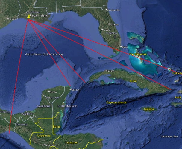
The two sea corridors are the Florida Straits and the Yucatan Channel. In the Florida Straits, the northern line is drawn just south of Marco Island and Homestead and the southern line is drawn just south of Key West. The southbound azimuth is the Isthmus of Tehuantepec.

Breaking out the spherical trigonometry, the Florida Straits provide a window for inclinations around 36 - 38 degrees and the Yucatan Channel provides a window for inclinations between 54 and 61 degrees. Flying directly over the Isthmus of Tehuantepec is very close to a sun-synchronous orbit at 98 degrees.
Now, working backwards from the common Starlink inclinations, we get four new azimuths.

These azimuths look something like this:
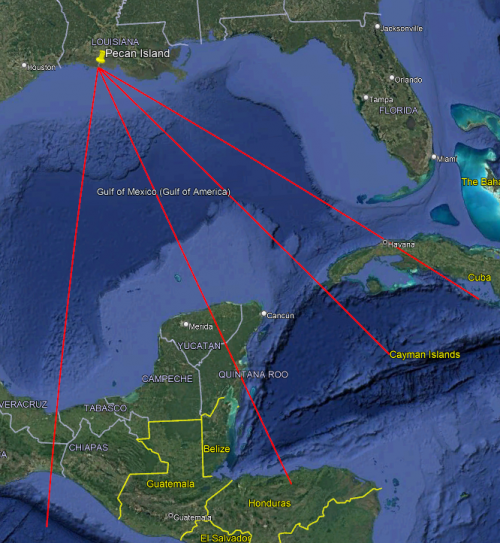
If the Starship failures have created a danger zone at roughly 2,500 km downrange, the only place that is over land along the paths from Pecan Island is the Costa Rica - Panama border region and the island of Hispanola.
- Joined
- 3 June 2011
- Messages
- 21,073
- Reaction score
- 19,479
Brett Davidson
ACCESS: Top Secret
- Joined
- 26 September 2006
- Messages
- 4,472
- Reaction score
- 12,906
Again - but it's not so bad this time.so it looks like the yucatan is in for a bad time

Forest Green
ACCESS: USAP
- Joined
- 11 June 2019
- Messages
- 14,714
- Reaction score
- 31,979
Attachments
Last edited:
Similar threads
-

-
 Strange Rockwell Hybrid Reusable Launch System (RLV)
- Started by Akagi_Apus
- Replies: 7
-

-
 McDonnell Douglas X-33 SSTO Reusable Launch Vehicle
- Started by athpilot
- Replies: 10
-
