If GPS system is completely disable what kind of weapon and sensors can still be used?

Vanessa1402

ACCESS: Confidential
Joined
10 April 2021
Messages
133
Reaction score
56
The majority of long range weapons nowadays rely on GPS guidance, but for the sake of discussion let say for some reason, all GPS system go offline, what kind of missile/bomb can still be used?
.JDAM, JASSM , JSM obviously become useless? Since they need GPS guidance for long range guidance?
Similarly, SAR mode on radar become useless as well? Because it need to track the distance the aircraft travel by GPS?
Aircraft likely can't perform SEAD anymore because their ESM sensor need aircraft location to geolocate exact location of radar through things like TDOA, triangulation?
 
1. Similarly, SAR mode on radar become useless as well? Because it need to track the distance the aircraft travel by GPS?
2. Aircraft likely can't perform SEAD anymore because their ESM sensor need aircraft location to geolocate exact location of radar through things like TDOA, triangulation?
1. No, it still has its INS
2. No, it is relative to the aircraft and not absolute.
 
When you say "all gps system" do you mean Multi-GNSS (Global Navigation Satellite System) including all of its component systems - GPS, GLONASS, Galileo, QZSS, and BeiDou?
 
The majority of long range weapons nowadays rely on GPS guidance, but for the sake of discussion let say for some reason, all GPS system go offline, what kind of missile/bomb can still be used?
.JDAM, JASSM , JSM obviously become useless? Since they need GPS guidance for long range guidance?
Similarly, SAR mode on radar become useless as well? Because it need to track the distance the aircraft travel by GPS?
Aircraft likely can't perform SEAD anymore because their ESM sensor need aircraft location to geolocate exact location of radar through things like TDOA, triangulation?
As Byeman mention - the impact will be mainly on accuracy, but all weapon systems still will be useful. Why? Because GPS was, and is external system to update INS - Inertial Navigation System that use gyroscopes for calculating position. GPS just help with fixes as INS systems always slowly degrade precision due to precession of the gyros. Moreover - some systems that are prepared to handle nuclear strike use Astro navigation as a way to provide fix to the INS. They do not relay on GPS as the assumption was, that due to EMP and ASAT GPS system will be anyway dead.
 
Hmm I would think maybe advanced tercom systems and maybe some kind of advanced radar relaying with INS systems? I'm guessing it would not be one system but many systems as the major powers already utilize.
 
1. No, it still has its INS
2. No, it is relative to the aircraft and not absolute.
. But INS need initial aircraft position right? And that position is from aircraft GPS right
I found this about JDAM
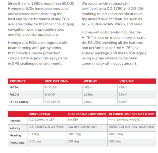
The heart of the JDAM is a Honeywell HG1700 Ring Laser Gyro (RLG) inertial unit, which measures position, velocities and accelerations in all three axes. The brain of the JDAM is in its Guidance and Control Unit (GCU), which contains an embedded microprocessor running a Kalman filter, which accepts position measurements from the GCU's HG1700 and a Rockwell GEM-III low cost military GPS receiver. The Kalman filter continuously computes a best estimate of the bomb's position in space. This information, and the preprogrammed target GPS coordinates, are then used to feed a flight control algorithm. HR Textron actuators are used to drive three of the four tail surfaces. Power is provided by a thermal battery in the JDAM tailkit. Most JDAM variants employ a set of strap on aerodynamic strakes, intended to increase body lift and also reduce the weapon's stability to improve its pitch and yaw rates, and thus manoeuvrability.

The flight control algorithm can be configured before launch for vertical or horizontal (ie shallow dive) terminal trajectories, selected by the user for a specific type of target. A weapon intended for the basement of a tall building could be programmed to enter at ground floor level, wheres a weapon intended to enter a bunker shaft could be programmed for a vertical trajectory.

The use of Kalman filter technology allows for refined midcourse flight algorithms, which can manage the weapon's kinetic energy and maximise glide range. Compared to the primitive analogue guidance in a baseline Paveway II, the JDAM achieves close to twice the glide range under similar launch conditions.

The JDAM employs the US standard Mil-Std-1760 umbilical interface, incorporating the Mil-Std-1553B digital multiplex bus. Before launch the JDAM's embedded software communicates with the launch aircraft's stores management processor, no differently than a computer peripheral. Prior to release the JDAM is powered up using an umbilical feed from the launch aircraft. The JDAM executes an internal self test, warms up and aligns the HG1700 inertial unit. Once the JDAM is ready, it communicates status information to the launch aircraft, which then downloads GPS timing, GPS Almanac (ie nav message), GPS Ephemeris (constellation) and the GPS PPS crypto key. This information is used to initialise the GEM-III receiver.

Once the inertial unit is aligned and the GPS receiver initialised, the launch aircraft can download into the bomb the target GPS coordinates, fuse settings and impact parameters, all of which can be reloaded at any time before release. Prior to release the aircraft's position and velocities are downloaded.

After the weapon is released, the thermal battery is initiated, the GPS receiver acquires a satellite constellation, and the weapon autonomously flies itself to impact, using pre-programmed parameters, penetrating cloud with no loss in accuracy. Should the GPS signal be impaired, lost or jammed, the weapon can rely on its inertial unit and will
 
As Byeman mention - the impact will be mainly on accuracy, but all weapon systems still will be useful. Why? Because GPS was, and is external system to update INS - Inertial Navigation System that use gyroscopes for calculating position. GPS just help with fixes as INS systems always slowly degrade precision due to precession of the gyros. Moreover - some systems that are prepared to handle nuclear strike use Astro navigation as a way to provide fix to the INS. They do not relay on GPS as the assumption was, that due to EMP and ASAT GPS system will be anyway dead.
What would be the accuracy of INS without GPS? Like 10-20 km?
 
What would be the accuracy of INS without GPS? Like 10-20 km?
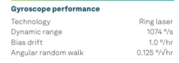
The drift rate of common INS system is 1 degree/ hours. I think supersonic and hypersonic missile will be less affected by the lack of GPS guidance compared to subsonic missile
A2D59D2A-C7C5-4CA8-B582-AD5CE42F84C1.jpeg
 
Vanessa1402 said:
What would be the accuracy of INS without GPS? Like 10-20 km?
No it doesn't work that way. The "error" (in distance) for an uncorrected INS increases in time. When you initialize an INS, you tell it exactly where it it is (some military airbases had the Lat/Long numbers painted on the hangar or on the ramp; the pilot would punch in that data as part of the alignment process.) Then, the system slowly drifts and your error increases. Modern systems are corrected by external reference means. That is to say, an external position is obtained and is used to correct the INS position. Then the gyros (Mechanical, laser or MEMS) continue to drift increasing your position error again until you update again.

Your uncorrected error will look like an unbroken diagonal line in a chart where x= time and y=error. An INS corrected by Astro or GPS (or by any number of external aids) will look like a sawtooth and stay at the bottom of the chart as the system goes through the "drift, correct, drift, correct, drift, correct..." routine ad infinitum.

Clear as mud?
 
There are many ways to provide fix to INS without GPS system. Fixed position is one, Astro navigation, TERCOM, TACAN and other radio navigation systems (check Wiki), SAR and we learn couple of days ago than even HIMARS in flight can be updated via datalink. There are many more methods. Lack of GPS is just inconvenience, not show stopper.
 
Understand GPS is easy to jam or spoof in part due to its very weak signal as its only powered by the GPS satellite solar array, the USAF Red Flag Exercise is carried out with all GPS jammed to make it more realistic and similarly at Army 2021 Project Convergence GPS was jammed. New M-code GPS said to be much harder to jam though how the new gen Raytheon ground stations, Next Generation Operational Control System (OCX) $ billions over budget and years late effect system unknown or if the new Lockheed GPS satellites where to be ever taken out. Currently substantial DOD R & D funding for alternative navigational systems under the PNT (Positioning, Navigation and Timing) banner e.g. one of many techs being looked at is Quantum navigation.
 
Last edited by a moderator:
No it doesn't work that way. The "error" (in distance) for an uncorrected INS increases in time. When you initialize an INS, you tell it exactly where it it is (some military airbases had the Lat/Long numbers painted on the hangar or on the ramp; the pilot would punch in that data as part of the alignment process.) Then, the system slowly drifts and your error increases. Modern systems are corrected by external reference means. That is to say, an external position is obtained and is used to correct the INS position. Then the gyros (Mechanical, laser or MEMS) continue to drift increasing your position error again until you update again.

Your uncorrected error will look like an unbroken diagonal line in a chart where x= time and y=error. An INS corrected by Astro or GPS (or by any number of external aids) will look like a sawtooth and stay at the bottom of the chart as the system goes through the "drift, correct, drift, correct, drift, correct..." routine ad infinitum.

Clear as mud?
As shown by @Ronny , the drift rate of common INS system on PGM is 1 degree per hour. Does that mean after traveling for 1 hour, the missile is of course by 1 degree from original route?. For example: a JASSM traveling at Mach 0.9 will take around 30 minutes to travel 500km, and it will be off route by 0.5 degree or about 4.3 km from original destination point??
 
No it doesn't work that way. The "error" (in distance) for an uncorrected INS increases in time. When you initialize an INS, you tell it exactly where it it is (some military airbases had the Lat/Long numbers painted on the hangar or on the ramp; the pilot would punch in that data as part of the alignment process.) Then, the system slowly drifts and your error increases. Modern systems are corrected by external reference means. That is to say, an external position is obtained and is used to correct the INS position. Then the gyros (Mechanical, laser or MEMS) continue to drift increasing your position error again until you update again.

Your uncorrected error will look like an unbroken diagonal line in a chart where x= time and y=error. An INS corrected by Astro or GPS (or by any number of external aids) will look like a sawtooth and stay at the bottom of the chart as the system goes through the "drift, correct, drift, correct, drift, correct..." routine ad infinitum.

Clear as mud?
if INS on fighter drift, INS on weapon drift, make me think if there is datalink, will that make the drift even worse?
 
Well as far as the bomb (say a JDAM) is concerned, the drift rate on the [extremely low cost] strapdown INS is much higher that the aircraft system (if there are no GPS inputs to correct it). On the other hand TOF (time of flight) on the JDAM is on the order of fewer than five minutes, so there is not that much time for the error to build up.

For longer range problem sets (say 95 minute TOF) on a cruise missile, you turn to a different set of more costly navigation solutions to reduce error in the INS. The classic cruise missile solution for the '70s was TERCOM, (Terrain Contour Matching) where you correct your position against recognizable ground features as detected by radar or other means. (Now, how you accurately survey all the mountain ranges between you and the target deep in bad guy territory - that is a story I'd like to hear.)

As to datalink, I don't know how that guidance update method is implemented, particularly against moving targets, although I'd imagine that drift is one of the smaller elements in your error budget.
 
What would be the accuracy of INS without GPS? Like 10-20 km?
Depends on which INS, and what gyros.

A submarine's Ship's Inertial Navigation System would drift fractions of a nautical mile per day, IIRC. But that's a particularly accurate and low-drift system.

Aircraft ring-laser gyros aren't quite as accurate.

The Mk27 gyro compass is rather crap in comparison, but it's still kept as a reserve.
 
Just armchair speculation here, but there are now a huge amount of satellites in orbit with known positions, orbits and emissions. It would be entirely feasible to create an astronavigation-type system that works off these. I'm sure a lot of communications satellites also transmit timestamps that could be leveraged to generate a pseudo-gps.
 
I think there are two way to overcome the lack of GPS guidance:
1- Alternative long range guidance such as passive radio sensor: AARGM-ER, JSM, LRASM
2- High speed to reduce engagement time: AARGM-ER, HACM, ASM-3
 
Hmm I would think maybe advanced tercom systems and maybe some kind of advanced radar relaying with INS systems? I'm guessing it would not be one system but many systems as the major powers already utilize.
"Advanced TERCOM"? Tomahawk and AGM-86 had it in the 70s.
 
It be fairly easy to make damn near all but the highest performance INS an ASTRO one.

A simple cheap staring camera array with the programing is basically the biggest add on to allow that.

The only weapons that you cant do that do are basically the artillery shells due to the forces, up to 20,000 Gees in both directions, they undergo.

And their IMU are still good enough for sub 15 meter accuracy which is more then good enough for most work.


That to say nothing of cutting some reach range for more loiter range for weapons with active sensors. The electro optical, active radar and similar types. To allow them to run a search pattern to find the target. That be an even easier theing to reprogram over modifications to add a scanning array.
 
It be fairly easy to make damn near all but the highest performance INS an ASTRO one.
A simple cheap staring camera array with the programing is basically the biggest add on to allow that.
Most system that used Astro navigation seem to be the very high altitude one, like ICBM, SR-71 ..etc. I think only at very high altitude they can see the star clearly. For cruise missile then Astro navigation might not be idea.

The only weapons that you cant do that do are basically the artillery shells due to the forces, up to 20,000 Gees in both directions, they undergo.
And their IMU are still good enough for sub 15 meter accuracy which is more then good enough for most work.
I think it has to do with the fact that artillery shell spend very little time flying and their range is not very far.
Assuming the bias drift rate of IMU in 155 mm artillery round is same as HG1700 which is 1 °/hour. The time of flight is 75 seconds to reach target 21 km away. So the angular drift would be 0.02°. For target at 21 km away, the drift is 7 meters from target position.
But for subsonic long range missiles, their time of flight is very long, so it lead to bigger miss distance
 
Most system that used Astro navigation seem to be the very high altitude one, like ICBM, SR-71 ..etc. I think only at very high altitude they can see the star clearly. For cruise missile then Astro navigation might not be idea.
Submarines can use star sights for navigation references through the periscopes, and did up until GPS was regularly available. I believe it's still a practice now, as a backup.

Looking through all the atmosphere probably reduces the accuracy of the fix somewhat, but it's not impossible.


I think it has to do with the fact that artillery shell spend very little time flying and their range is not very far.
Assuming the bias drift rate of IMU in 155 mm artillery round is same as HG1700 which is 1 °/hour. The time of flight is 75 seconds to reach target 21 km away. So the angular drift would be 0.02°. For target at 21 km away, the drift is 7 meters from target position.
But for subsonic long range missiles, their time of flight is very long, so it lead to bigger miss distance
They can still be given an astro upgrade.
 
Most system that used Astro navigation seem to be the very high altitude one, like ICBM, SR-71 ..etc. I think only at very high altitude they can see the star clearly. For cruise missile then Astro navigation might not be idea
Most of the things that used Astroinertial were either fairly old systems (SR71) or need self contain navigation though (ICBM). With the gear being used being large.

With it not being till the mid 2000s that tech would have allowed for a small compact astro sensor. Before that you had to deal with a decent chunk of the system needing to be the lenses and gearing to see the stars and measure their angles. Which balloon the need space to a fairly large set up.

By the time that got miniaturized GPS was consider well and truly the king of navigation with even the USN dropping celestial Navigation, the manual Astronavigation, from its training.

Until recently there really wasn't much looking into improvement or using modern gear in astronavigation.

Which is a shame cause modern tech allows for many fun tricks to be done. Up to basically only needing half a cellphone to make it work.
 
US investment and advancement in AINS effectively ended in the early 1990's when strapdown AINS was on the verge of demonstration. Google up "Strapdown Astro-Inertial Navigation Utilizing the Optical Wide-angle Lens Startracker (OWLS)." This system was to discard and replace the moving telescope and the vidicon tube technology while decreasing power, cooling and space requirements.
 
Most system that used Astro navigation seem to be the very high altitude one, like ICBM, SR-71 ..etc. I think only at very high altitude they can see the star clearly. For cruise missile then Astro navigation might not be idea.
not true. See Snark, Navaho, and others.
 
With it not being till the mid 2000s that tech would have allowed for a small compact astro sensor. Before that you had to deal with a decent chunk of the system needing to be the lenses and gearing to see the stars and measure their angles. Which balloon the need space to a fairly large set up.
Small ones go back further
 
Why not a combination of TERCOM, LIDAR and artificial intelligence?
Goes back to CONOPS, requirements and budget.

TERCOM emits, requires mapping beforehand and needs to fly over recognizable terrain. It can be cheap and does not need much in the way of SWAP. Is best suited for a weapon at the lower end of the scale.

At the other end of the scale, AINS has no emissions, is can not be jammed or spoofed, and cares not what it flies over (or under); and has no external signal requirements other than that the stars keep shining. Even in daylight. But is very expensive and is best suited for a high end weapon or delivery platform.


Honest question - of what possible use [improvement] is AI? Navigation is an extremely well-known problem and the physics is not going to change (I hope!).
 
But is very expensive and is best suited for a high end weapon or delivery platform.
I honestly doubt that its even that much more expensive any more.

Since alot of things that made it expensive, the digital memory and digital cameras with decent lenses have come WAY down since even the OWL.

So a modern GPS/AINS likely only slight bit more expensive then the standard. The Bigger issue is getting the cameras line of sight.
 
The majority of long range weapons nowadays rely on GPS guidance, but for the sake of discussion let say for some reason, all GPS system go offline, what kind of missile/bomb can still be used?
.JDAM, JASSM , JSM obviously become useless? Since they need GPS guidance for long range guidance?
Terrestrial/airborn radio beacons can replace GPS with lower cost and higher power, with only problems of coverage. At tactical ranges, unless you need a full passive solution it should be the easiest and cheapest option I'd think.
 

Similar threads

Back
Top Bottom