
You are using an out of date browser. It may not display this or other websites correctly.
You should upgrade or use an alternative browser.
You should upgrade or use an alternative browser.
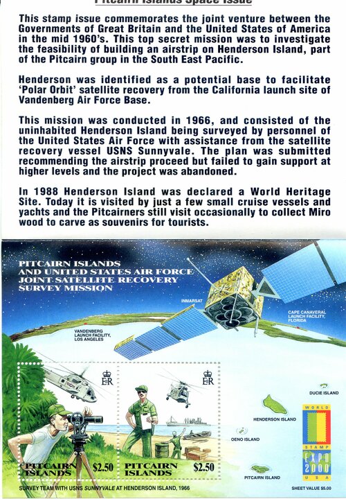
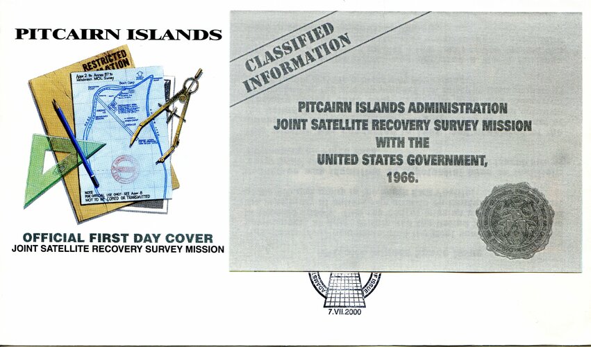
Henderson Island Satellite Recovery Survey Mission
- Thread starter sat_dxer
- Start date
- Joined
- 26 September 2008
- Messages
- 1,925
- Reaction score
- 641
This is kinda odd. I can't see any value in recovering satellites from orbit at that location. I wonder if there was interest in building some kind of tracking facility there for launches out of Vandnberg?
USNS Sunnyvale was the regular ship used in recovery of reconnaissance satellite capsules from orbit. C-130s flying out of Hawaii would do the recoveries, but Sunnyvale provided backup support in case a capsule landed in the water.
USNS Sunnyvale was the regular ship used in recovery of reconnaissance satellite capsules from orbit. C-130s flying out of Hawaii would do the recoveries, but Sunnyvale provided backup support in case a capsule landed in the water.
Nik
ACCESS: Top Secret
- Joined
- 15 July 2009
- Messages
- 1,149
- Reaction score
- 820
Would a short photo-recon mission out of Vandenberg crossing near Pitcairn cross any time-sensitive USSR sites that would be worth the trouble ?
IIRC, a lot of 'alternate' film capsule plans were abandoned after satellites became able to process and scan on-orbit...
IIRC, a lot of 'alternate' film capsule plans were abandoned after satellites became able to process and scan on-orbit...
No, It was the other way around. Only 3 process and scan on-orbit reconn sats flew in total (excluding Lunar Oribter). The process and scan on-orbit concept was quickly abandoned and more 'alternate' film capsule plans were used (SAMOS E5& E6) or investigated (PRIME)IIRC, a lot of 'alternate' film capsule plans were abandoned after satellites became able to process and scan on-orbit...
Maybe just an emergency strip for the JC-130sThis is kinda odd. I can't see any value in recovering satellites from orbit at that location. I wonder if there was interest in building some kind of tracking facility there for launches out of Vandnberg?
USNS Sunnyvale was the regular ship used in recovery of reconnaissance satellite capsules from orbit. C-130s flying out of Hawaii would do the recoveries, but Sunnyvale provided backup support in case a capsule landed in the water.
- Joined
- 26 September 2008
- Messages
- 1,925
- Reaction score
- 641
Maybe just an emergency strip for the JC-130sThis is kinda odd. I can't see any value in recovering satellites from orbit at that location. I wonder if there was interest in building some kind of tracking facility there for launches out of Vandnberg?
USNS Sunnyvale was the regular ship used in recovery of reconnaissance satellite capsules from orbit. C-130s flying out of Hawaii would do the recoveries, but Sunnyvale provided backup support in case a capsule landed in the water.
Look it up on a map. It's nowhere near Hawaii. So if that organization was interested in that location, it had something to do with satellite recovery.
Or perhaps as an airbase to keep an eye on the French nuclear tests (post 1966) in Polynesia?
"U-2s on carriers" took care of this, but I agree that solid ground might have been preferable...
- Joined
- 26 September 2008
- Messages
- 1,925
- Reaction score
- 641
No, It was the other way around. Only 3 process and scan on-orbit reconn sats flew in total (excluding Lunar Oribter). The process and scan on-orbit concept was quickly abandoned and more 'alternate' film capsule plans were used (SAMOS E5& E6) or investigated (PRIME)IIRC, a lot of 'alternate' film capsule plans were abandoned after satellites became able to process and scan on-orbit...
The more accurate term is film-readout. They took a picture with film, developed the film, then ran the film through a light scanner that converted the image to a radio transmission that was sent to the ground. You're right that it was quickly abandoned. Here is a quick list of US reconnaissance systems:
Samos E-1: film-readout
Samos E-2: film-readout
Samos E-3: a kind of film-readout, but canceled at the study stage
Samos E-4: film-return (mapping system, never flew)
Samos E-5: film-return
Samos E-6: film-return
KH-1 to KH-4B CORONA (all versions): film-return
KH-5 ARGON: film-return
KH-6 LANYARD: film-return
KH-7 and KH-8 GAMBIT: film-return
FROG: Film Read Out Gambit (never flew)
KH-9 HEXAGON: film-return
KH-10 MOL/DORIAN: film-return
KH-11 KENNEN: electro-optical (beamed its images to the ground)
Film is a very high-density storage medium. It can hold a lot of data. It vastly outperformed all other technologies for a long time. Although the details are classified, there is reason to believe that even into the 1990s the digital systems could not provide as much imagery as some of the film systems for a given period of time.
Wasn’t thinkingMaybe just an emergency strip for the JC-130sThis is kinda odd. I can't see any value in recovering satellites from orbit at that location. I wonder if there was interest in building some kind of tracking facility there for launches out of Vandnberg?
USNS Sunnyvale was the regular ship used in recovery of reconnaissance satellite capsules from orbit. C-130s flying out of Hawaii would do the recoveries, but Sunnyvale provided backup support in case a capsule landed in the water.
Look it up on a map. It's nowhere near Hawaii. So if that organization was interested in that location, it had something to do with satellite recovery.
sat_dxer
ACCESS: Confidential
- Joined
- 8 July 2020
- Messages
- 70
- Reaction score
- 68
Similar threads
-
 God’s eye view: HEXADOR and the very high resolution satellite
- Started by Flyaway
- Replies: 2
-

-

-
 Air Staff Target 9003 Photo-Reconaissance Satellite (Early 1960s)
- Started by A Tentative Fleet Plan
- Replies: 6