- Joined
- 21 April 2009
- Messages
- 13,155
- Reaction score
- 6,018
https://imgur.com/gallery/Av1ywuD
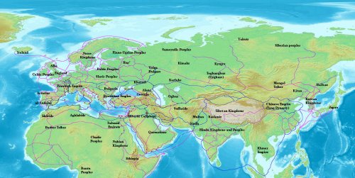
Even before modern times the Afro-Eurasian world was already well connected. This map depicts the main trading arteries of the high middle ages, just after the decline of the Vikings and before the rise of the Mongols, the Hansa and well before the Portuguese rounded the Cape of Good Hope. The map also depicts the general topography, rivers, mountain passes and named routes. All of which contributed to why cities came to be, and still are, up until modern times. The high middle ages were a time when the stars aligned in terms of commerce for many areas of the world. In central Europe many German and French cities initiated annual trade fairs, some of which are still active today - most notably in Frankfurt. The Europeans have redeveloped a demand for eastern goods as a result of the crusades in Iberia and the Levant. The Italian city states and some north eastern Iberian cities had shipped the crusaders back and forth in the Mediterranean sea, building up huge fleets and setting up networks of trade all around the Mediterranean shores. The Italians frequented ports such as Alexandria, which had separate trading ports for muslim and christian ships.