Laser-based communication systems

AN/AWW-14(V)

ACCESS: Granted
Senior Member
Joined
18 May 2019
Messages
636
Reaction score
1,569
SpaceDataHighwaySatellites.jpg


General Atomics Aeronautical Systems completed live ground testing of the company’s Airborne Laser Communication System (ALCoS), using the laser-based communication system to establish a datalink with a satellite operating in geosynchronous orbit (GEO) for the first time.

During the test, the ALCoS platform linked with Laser Communication Terminal (LCT) 135 aboard Tesat-Spacecom’s GEO satellite Alphasat, utilising laser-based, air-to-space communications technologies with size, weight, and power (SWaP) characteristics of a system that can be operated aboard a medium-altitude, long-endurance (MALE) unmanned aircraft system (UAS), a 20 February company statement said.

“The test successfully demonstrated acquisition and tracking, and sufficient power to close the link with the LCT 135,” under the SWaP requirements, company officials said.

 
PRODUCT RANGE AND APPLICATIONS OF LASER COMMUNICATION TERMINALS BY TESAT

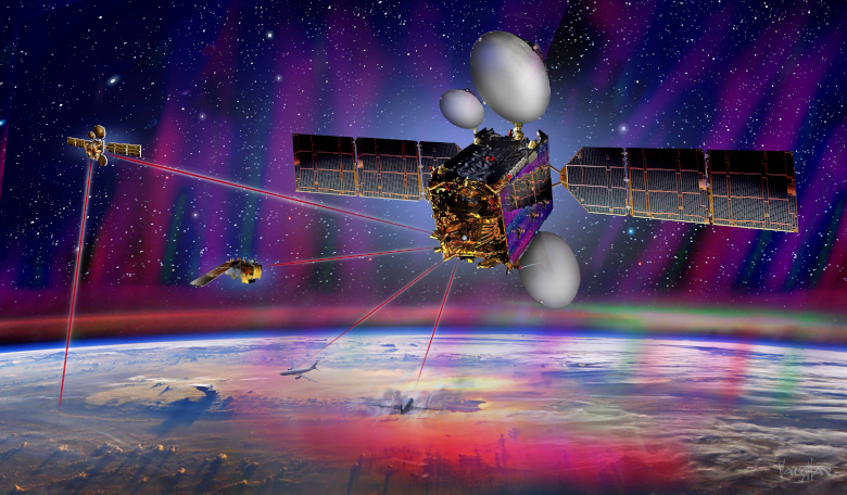
Exactly ten years ago on 21st February, 2008, a government-to-government cooperation between the United States and Germany to establish a laser link between two operational satellites in Low Earth Orbit (LEO) started a new chapter in the history of space. The German radar satellite TerraSAR-X and the U.S. Missile Defense Agency satellite NFIRE, both equipped with Laser Communication Terminals (LCT) manufactured by Tesat, established the first successful and stable orbital laser link.

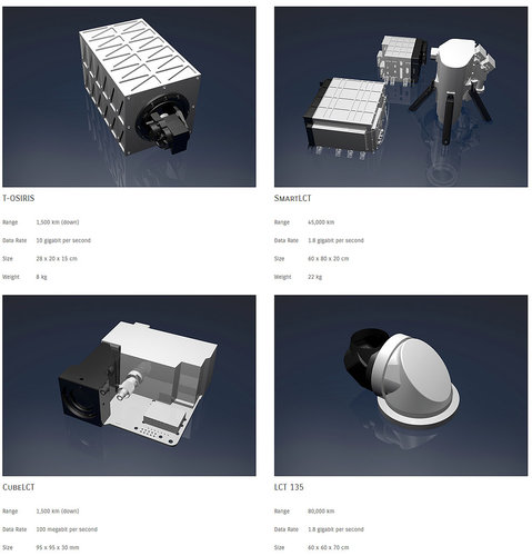
The anniversary terminal “LCT 135” makes it possible to send up to 1.8 Gbps of data and information over a distance of up to 80,000 km, fast, secure and totally interference-resistant – even when both satellites drift away from each other in different orbits at absolute orbital speeds of around 30,000 kilometres per hour.

Tesat's LCTs are the key technology behind Airbus's SpaceDataHighway that provides near-real-time data transmission to any location worldwide. This system of two geostationary satellites is used to relay data between Low Earth Orbit (LEO) satellites, spacecrafts or airborne platforms and fixed ground stations. Thus Tesat‘s technology enables near-real time data provision in support of time-critical and data-intensive applications such as for emergency response actions following natural disasters. Another exemplary application area is in the support of global maritime surveillance activities as in the upcoming Pléiades Neo Constellation of Airbus, which also will utilise the SpaceDataHighway to ensure highest system reactivity, lowest latency and high volume data transfer.

Building on more than 30 years of experience in developing and improving laser communications technology, experts at Tesat are developing smaller, smarter and more versatile solutions for a variety of new application areas. These include dedicated LCTs for LEO applications, for large satellite constellations, and also for CubeSats – small cube-shaped Earth observation or scientific satellites. Common to all terminals is the approach to reduce size, weight and cost, while maintaining functionality.

Tesat can offer appropriate Laser Terminals for a wide range of applications. In the case of the SpaceDataHighway, this is the LCT135, which can transmit up to 1.8 gigabits per second over distances of up to 80,000 kilometers, safely, quickly and completely fail-safe. Through this geostationary backbone, Tesat technology enables worldwide data transmission in near real-time.

For applications in Low-Earth Orbits (LEO) there is the SmartLCT, which can be deployed on smaller, lighter satellites with huge weight and size savings. Data transmission over distances of up to 45,000 kilometers while maintaining the high data rate of up to 1.8 gigabits per second, the SmartLCT weighs just about 22 kilograms.

For even smaller satellites, Tesat's Laser Portfolio offers the TOSIRIS and CubeL, which can transmit Direct-to-Earth data at speeds of 10 gigabits per second (TOSIRIS) or 100 megabits per second (CubeL). Particularly impressive is the associated reduction in weight. The already small representative TOSIRIS comes to only 8 kilograms while the CubeL with an edge length of just 10 centimeters weighs only 300 grams.

The groundbreaking feature is that Tesat LCTs are already helping to increase the satellite's reception capacity by up to 50%, as more data can be transmitted in less time. This makes it possible to re-record the entire global land mass (150 million km²) in just 5 days, while making it available in less than 15 minutes.
Tesat currently operates 8 Laser Communication Terminals in space – 2 of them on geostationary satellites in Airbus's SpaceDataHighway and 6 on LEO satellites.


Attachments

  • 65.jpg
    65.jpg
    129.8 KB · Views: 16
Last edited:
Short Flight International article on the General Atomics test:


Not going to put a giant wall of text from one of them but parts of it to show what they are talking about.

"The invention relates to the field of laser ranging. The near-Earth space monitoring laser device contains an auxiliary laser radiation source mounted on the first optical axis, an angular mode selector with a first resonator mirror, a working laser radiation generator, a translucent radiation output mirror, and a second resonator mirror. Behind the output mirror, a fully reflecting mirror, a working radiation amplifier, a spectro-splitting mirror, the first and second rotary support devices (OPU) are installed. The reflective surfaces of the OPU mirrors are installed counter to each other. Behind the rear edge of the spectrodividing mirror, there are video surveillance and position monitoring tools for a remote object, as well as an optical-electronic device for recording reflected probe radiation. On the optical axis, not matching the first, a location module is located that includes a probe laser source sequentially installed on the optical axis, means for generating a spatial profile and probe radiation divergence, fully reflecting the probe probe radiation transportation system, third and fourth control devices, video surveillance and monitoring of the position of a remote object . The reflective surfaces of the OPU mirrors are installed counter to each other. The device also contains an automated control system and control of operating modes associated with the system of topographic and geodetic and time reference. The technical result is to expand the volume of controlled outer space. 13 s.p. f-ly, 4 ill. including a probe laser radiation source sequentially installed on the optical axis, means for forming a spatial profile and divergence of probe radiation, a fully reflecting mirror system for probe radiation transport, third and fourth GPCs, video surveillance and monitoring tools for the position of a remote object. The reflective surfaces of the OPU mirrors are installed counter to each other. The device also contains an automated control system and control of operating modes associated with the system of topographic and geodetic and time reference. The technical result is to expand the volume of controlled outer space. 13 s.p. f-ly, 4 ill. including a probe laser radiation source sequentially installed on the optical axis, means for forming a spatial profile and divergence of probe radiation, a fully reflecting mirror system for probe radiation transport, third and fourth GPCs, video surveillance and monitoring tools for the position of a remote object. The reflective surfaces of the OPU mirrors are installed counter to each other. The device also contains an automated control system and control of operating modes associated with the system of topographic and geodetic and time reference. The technical result is to expand the volume of controlled outer space. 13 s.p. f-ly, 4 ill. a fully reflecting mirror system for the transportation of sounding radiation, the third and fourth OPU, video surveillance and monitoring of the position of a remote object. The reflective surfaces of the OPU mirrors are installed counter to each other. The device also contains an automated control system and control of operating modes associated with the system of topographic and geodetic and time reference. The technical result is to expand the volume of controlled outer space. 13 s.p. f-ly, 4 ill. a fully reflecting mirror system for the transportation of sounding radiation, the third and fourth OPU, video surveillance and monitoring of the position of a remote object. The reflective surfaces of the OPU mirrors are installed counter to each other. The device also contains an automated control system and control of operating modes associated with the system of topographic and geodetic and time reference. The technical result is to expand the volume of controlled outer space. 13 s.p. f-ly, 4 ill. associated with the system of topographic and geodetic reference. The technical result is to expand the volume of controlled outer space. 13 s.p. f-ly, 4 ill. associated with the system of topographic and geodetic reference. The technical result is to expand the volume of controlled outer space. 13 s.p. f-ly, 4 ill.


The invention relates to the field of laser ranging, to guidance systems, visualization, as well as to laser technology for irradiating a distant target (object) and can be used to clean outer space from particles of space debris and other objects that are dangerous for modern aircraft."
 
If you are interested in laser-based communication systems, you could try asking on https://reddit.com/r/lasercom. Essentially General Atomics is just one player out of many. The space primes includes SpaceX Starlink, Mynaric, Ball Aerospace, Thales Alenia Space.

The space agencies working on lasercom include ESA, NASA, JAXA (Japan), CNSA (China), Russia, and to some extent ISRO (India).

Government agencies investing in lasercom right now include DARPA (with their Blackjack program), the US Army, and the Space Development Agency (SDA).
 
Now, I seem to remember a passive millimetric wave ‘camera’ that saw through fog. Good for stormchasing. I wonder if these optics can be combined
 

Similar threads

Back
Top Bottom