Yellow Palace
ACCESS: Top Secret
- Joined
- 5 May 2007
- Messages
- 1,023
- Reaction score
- 1,645
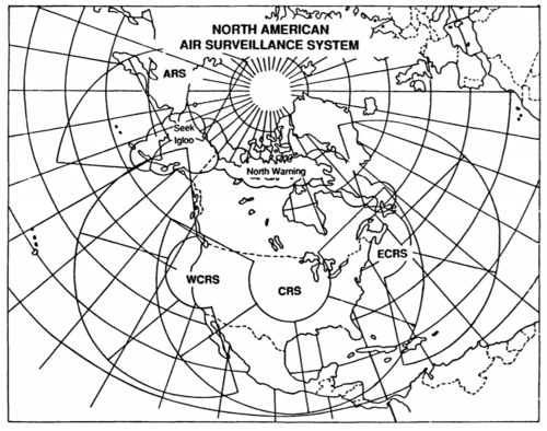
The Alaskan Radar System was to have the transmitters located near Gulkana, the receivers at Tok, and the operations centre at Elmendorf AFB. Work began on the first sector, with the transmitter site being repurposed for use by the High-Frequency Active Auroral Research Program (HAARP).The OTH-B program consists of four separate systems, each containing two or more integrated sectors. Each sector provides area coverage between 500 and 1,800 nautical miles from the radar site, over a 60-degree azimuth. The East Coast Radar System (ECRS), which is located in Maine, contains three sectors that provide 180 degrees of coverage primarily ovw the Atlantic Ocean and extend from Greenland to the West Indies. The West Coast Radar System (WCRS) also contains three sectors that provide 180 degrees of coverage primarily over the Pacifi Ocean and extend from Alaska almost to Mexico. The transmitters, receivers and operations center are located in Oregon, California, and Idaho, respectively. The Alaskan Radar System (ARS) is planned to contain two sectors that would provide 120 degrees of coverage over a portion of the North Pacific Ocean, the Aleutian Islands, and a portion of the Soviet Union. THe Central Radar System (CRS) is planned to contain four sectors that would provide 240 degrees of coverage. CRS's two inner sectors would extend south beyond the United States and include the Gulf of Mexico, portions of the Caribbean Sea, most of Mexico, and a portion of the eastern Pacific Ocean. Its two outer sectors would provide coverage of ocean areas called "skip zones" near the east and west coasts of the United States that are not covered by ECRS and WCRS. The transmitters, receivers, and operations centre are to be located in South Dakota, Minnesota, and North Dekota respectively. Altogether, the four OTH-B systems contain 12 sectors. However, one of the ARS sectors and the two outer CRS sectors are not currently included in the Air Force's program baseline because of budget constraints. The North American Aerospace Defense Command (NORAD), nevertheless, stated that 12 OTH-B sectors were still needed for the air defense mission.
The Central Radar System was to have four sectors, covering an azimuth range of 56 to 296 degrees. The transmitters were to be located near Amherst, South Dakota; the receivers near Thief River Falls in Minnesota, and the operations centre at Grand Forks AFB in North Dakota.
By 1990, the programme called for contract award for the single-sector ARS in 1990 (on a 54 month construction schedule, implying completion in 1994/1995), and procurement for the CRS to begin in 1991.
The CRS was originally planned to be based further south, around Texas and Oklahoma, with two sectors primarily to detect bombers. The southerly basing location would give the greatest radar coverage, hence warning time. The emergent cruise missile threat in the 1980s saw the site moved further north to improve close-in cover. I suspect that this was also when the two outer sectors were added to cover the coastal blind spots of the ECRS and WCRS.
It's worth noting that the North Warning System was part of the same programme - the OTH-B radar was incapable of looking polewards, so a line of conventional radars was needed to close the gap. SEEK IGLOO provided a similar capability in Alaska.
Over-the-Horizon Radar - Better Justification Needed for DOD Systems' Expansion
Final Environmental Impact Statement - Proposed Alaskan Radar System
Technical Studies - Central Radar System:
Department of the Air Force - Supporting Data for FY 1991 Budget Estimates
The CRS technical studies report also provides a coverage map for the full planned system, including the North Warning System and SEEK IGLOO, which I've attached.